(This post is part of my series on the Basque Country. Click here for Bilbao, here for San Juan de Gaztelugatxe, and here for San Sebastián.)
The train pulled up to Portugalete station, the doors opened, and we got off. Portugalete is one of the towns, ranged along the Bilbao river, that make up the Bilbao metropolitan area. (The name’s resemblance with “Portugal” is apparently only a coincidence.) With a population of about 50,000, and a land area of only 3.21 square kilometers, it is actually the fifth most densely populated area in Spain.
To me, the place struck me as a pleasant, moderately urbanized, more or less tranquil town. Along the riverside there were some large, attractive restaurants, their tables crowding into the streets—though at this hour, too early for dinner in Spain, the chairs were mostly empty. But the surroundings didn’t attract my attention for long, since I could already see my goal: the Vizcaya Bridge.
In Spanish it is called the Puente Colgante, or “Hanging Bridge.” The name is appropriate. It is a perplexing sight at first. The bridge has the familiar form of a suspension bridge; but the middle section seems to be misplaced: it hangs ludicrously high in the air, with no ramps to get up or down. The more I looked, the more confused I became, for there didn’t seem to be any way you could use the bridge.
As I got nearer, I noticed something strange on the water. It wasn’t quite on the water, actually, but hovering above it. I looked up, and saw that the thing was hanging from the bridge. So that’s how it worked! The reason the bridge looked so odd was that it transported a shuttle that hung underneath, almost like a puppet on strings. That’s why the bridge was so high up and there weren’t any ramps to get on.
But it looked dangerous to me. The shuttle was fairly large; it transported about six cars and one hundred people. Could that skeletal iron structure above support so much weight? Dreadful fantasies immediately started rushing to my mind. I saw the bridge snapping in the middle, sending iron raining down into the river below, crushing the shuttle and sending everyone inside to a watery grave. Unfortunately, awful visions like this plague me rather frequently. I wonder if it’s the product of a morbid imagination, or just watching too many action movies.
We went into the office and bought our tickets, though I wasn’t sure what the tickets were for. The man explained that there was an elevator to take you up to the top, where you could walk to the other end. He also gave us a little information pamphlet about the bridge. From this, I learned that the bridge is actually a UNESCO World Heritage site, the only monument in the Industrial Heritage category in Spain.
I also learned more about the construction and history of the bridge. The Vizcaya Bridge is a transporter bridge, the first of its kind in the world. If you haven’t heard of a transporter bridge before, that is perfectly normal, since this type of bridge is uncommon; according to Wiki, less than two dozen were built, and only 12 still stand today.
The Vizcaya Bridge, finished in 1893, was designed by one of Gustave Eiffel’s disciples, Alberto Palacio; and Eiffel’s influence shows. The bridge is built in the same manner as the Eiffel Tower, with narrow iron beams riveted together to form a triangular grid; and like the Eiffel Tower, the Vizcaya Bridge is austere and elegant. Palacio originated the idea in response to a common engineering problem: how do you create a bridge that allows people and cars to cross the river, while leaving the river open for shipping vessels? The Vizcaya bridge, then, in both purpose and execution, is a symbol of the Basque Country’s embrace of industry, commerce, and the future—not to mention art.
(I do wonder, though, whether Palacio’s solution was all that efficient. After all, there must be a reason why the design didn’t catch on. The primary problem, it seems to me, is that the amount of cars and people that can cross at any one time is limited by the size of the shuttle and the frequency of its trips. Perhaps the famous Tower Bridge in London—completed almost the same year—solved the problem more satisfactorily, by putting a drawbridge on the lower level and a pedestrian walkway on the upper. But Palacio’s design is beautiful, original, and elegant, so efficiency can go to the devil.)
Finally it was our turn for the elevator. It was an ancient thing, crawling up the bridge at a snail’s pace. Eventually the lift creaked to a halt, and we got out. A narrow wooden walkway, surrounded by the iron structure, extended from one end of the bridge to the other. It’s really amazing how much of the Vizcaya Bridge is just air. You can see right through the thing, and yet it is strong enough to support the weight of a large shuttle carrying six cars.
I experienced this when one of the shuttles came rolling by, right underneath our feet. I could feel the entire bridge shaking, rattling, and shivering, as the electrical buzzing of the engine roared past. Once again, terrible fantasies started flickering through my mind, this time with me myself plunging to a ghastly death. But soon the shuttle came to a halt, and I realized that the bridge was solid as stone. What an impressive achievement: The bridge seems to float high up in the air, supported by the slenderest structure; and yet it is sturdy enough to remain operational after more than one hundred years of daily use.
We took some time to admire the view. On one side we could see the bay, and then the ocean beyond. In the dockyard in the distance, I could see dozens of giant cranes standing silently, like petrified dinosaurs, waiting to come back to life. On the other side, we could see the river gradually making its way towards Bilbao; and in the distance, a factory loomed. Really, wherever you turned you could not fail to notice the signs of industry, filling up the entire estuary with their jagged, colossal, metallic forms. Below us, we could see the towns of Portugalete on one side and Getxo on the other, their streets now full. We might have stayed more time up there, but the wind was quite strong and chilly, so we took the elevator down on the other side. Not long after that, we took the shuttle from Getxo across the river, back to Portugalete; and I am happy to report that the ride was quick and smooth.
There is only one thing more I have to report. Before we left, GF had asked some of her students in Madrid where you can buy good pizza, and they told her to go to Telepizza (a popular chain here, comparable to Dominoes). That sounded awful to me, but GF wanted to try it; so, once we got to Portugalete, we decided to go to the nearest Telepizza for dinner. It brings me no joy to tell you that, as I expected, the pizza was horrible, some of the worst pizza I’ve ever had; and GF was of the same opinion. Is this what Spanish people think pizza is supposed to taste like?
(This post is part of my series on the Basque Country. Click here for Bilbao, here for the Vizcaya bridge, and here for San Sebastián.)
I always find public transportation a bit nerve-racking—especially in a new city, not to mention a foreign country. Every time I hop on a bus, I feel like I’m taking a leap of faith. I imagine taking the wrong bus and getting stranded in the middle of nowhere, or taking the right bus and getting off on the wrong stop—and these fears aren’t totally unfounded, as I’ve done both of these things. Thus I was filled with apprehension as we searched for the bus to Bakio, the A3518.
Probably you have never heard of Bakio, because there isn’t much to be heard about it. Bakio is a small town, with a population of about 2,500, situated about 30 kilometers from Bilbao. There is admittedly a beach there, although the damp, chilly, overcast weather of the region didn’t exactly put me in the mood for surfing. Rather, we were going to Bakio because it was the closest we could to get by bus to San Juan de Gaztelugatxe.
The town of Bakio
The bus ride to Bakio was quite pleasant, taking us through the green countryside, filled with little huts and farmhouses tucked away into the rolling hills. After 40 minutes we arrived, ate some breakfast, and then set on our way. I had found a little report online (found here), written by somebody who had walked from Bakio to Gaztelugatxe. And attached in that report is a little map, with the walking route conveniently highlighted. But for whatever reason I forgot about this map as we started walking. Instead I chose to rely on my phone’s GPS to guide me there. Please, don’t make this mistake: just follow the walking route.
GF and I soon found ourselves walking along a busy road, with no sidewalks.
“Are you sure this is the right way?” she said.
“Yeah, I’m just following my phone.”
“Okay…”
We walked further, and after a while came to a sharp curve in the road. Because there wasn’t any sidewalk, and the road was hemmed in by a rockface on one side and some trees on another, we found ourselves in the predicament that, no matter which side we chose, we would risk making ourselves invisible to an incoming car. Thankfully, the cars only came periodically, with big gaps in-between; and we hoped we’d be able hear them a ways off. Still, it was nerve-racking as we rushed around the corner, trying to minimize our time on the curve.
“I hope there aren’t any more curves like that,” GF said as we got to the other side.
“Me too,” I said.
But five minutes later, we came to another curve. And then another, and another. The entire road, it seemed, wrapped around the hills like a snake, constantly turning left and right. Meanwhile, the amount of cars on the road seemed to be steadily increasing.
“I don’t like this,” GF said. “Is there any way off this road?”
“Umm,” I said, “maybe up ahead.” (I had no idea.)
During the stretches of straight roads, I did my best to enjoy the scenery. It was a nice place, with pine trees and farmhouses all around, and the occasional view of the countryside beyond. But the whoosh of a passing cars destroyed any peace to be had; and the sight of every sharp turn ahead increased my anxiety.
There was over an hour of this, the two of us walking on through the brush and bushes by the side of the road, our feet searching for stability amid the roots and rocks, changing sides whenever it seemed more safe, pressing ourselves against the trees whenever a car went past, rushing around curves with our adrenalin racing, GF nervously complaining while I tried to keep my own fears to myself. And then, finally, just as I was at my wit’s end, the hermitage came into view.
“Yes!” GF said, filled with relief.
§
San Juan de Gatztelugatxe (recently made famous in Game of Thrones, as the location of Dragonstone) is an island off the coast of Biscay, connected to the maindland by a man-made bridge. Since at least the 10th century, a little religious building has been perched up at the top of it, though it has burnt down and been rebuilt many times, most recently in 1980.
To get there from the road we had to climb down towards the shore. The path was steep, twisting, and rocky. Even though you’re going down hill, it is exhausting because you need to be constantly on guard against falling. At last we got near the bottom, where there was a lookout point from which we could get a good view of the island.
It must be one of the most astonishing sights in Spain. The island is a mound of jagged grey rock, covered in slight patches of green. Its splayed form stretches out into the sea, wherein it is battered day and night, on all sides, by the winds and the waves. In the middle of this island, criss-crossing its way up from the bottom to the top, is a staircase—usually filled with the miniscule forms of people going up and down. And crowning the island is the hermitage, a small shack with a dull red roof.
Perhaps this image is so appealing to me because I find in it a symbol of the relationship of humanity to nature. We have carved a staircase into the rock, and erected a place of worship on the summit of the island; and in this way we can be said to have dominated the place. And yet, how feeble our dominance of nature seems when viewed from a distance—just a pile of boards, liable to be blown away by the first strong gust. This is the age-old contest of craft, cleverness, and perseverance against capricious, indifferent power. And I cannot help thinking that, however successful we are now, there will come a day when the hermitage blows down, and there won’t be anyone to build it back up again.
But these gloomy thoughts were soon gone as I huffed and puffed my way up the staircase to the top of the island. By now we had been walking over an hour next to that road, our hearts in our throats all the while; so we were understandably a bit worn out. It felt all the better, then, when we finally reached the top, and could look back towards the land.
In the distance, to our right, we could see the beach of Bakio; and to the left, nothing but steep, grey cliffs and green forests. Gigantic rocks stuck out of the ocean, the biggest one almost as big as the island itself. To one side, far off, I could see what looked like an oil drill. Apart from that, no boats, no freighters, no planes broke the endless blue of the sea beyond or the grey of the sky above. It felt like standing at the edge of the world.
We couldn’t go inside the hermitage, nor even peek through a window. This didn’t bother me, however, since judging by the looks of the plain exterior, the interior would be similarly nondescript. What we could do was ring the bell. A string hung from the bell on the roof to the ground below, and all the visitors were taking turns having a pull (one kid got a bit too enthusiastic, and his parents had to keep him away). I gripped the chord and lightly tugged, and the satisfying clang of a church bell sounded overhead.
Since neither of us had any intention of repeating that dreadful walk by the road, this time I looked up the walking path on my phone. We found the path without any trouble, which made me feel like such an idiot for not using it the first time. It was such a relief! Instead of the twisting, turning road we had a straight path, free of cars, taking us through quiet countryside. We passed through a copse of trees, and then through some fields where cows were grazing, making our way over gently rolling hills, the seaside on our right, until we were finally back in Bakio. The bus soon arrived, and then we were on our way to Bilbao, where we still had one more thing to see.
The bus crawled out of Zaragoza’s main bus terminal, Delicias, and quickly left the city limits. It was early morning. The landscape was entirely shrouded in fog. It wasn’t long before I gave up trying to see the countryside and fell asleep. When I awoke—with a headache and a nasty taste in my mouth—we had parked in Catalayud, a small town midway between Zaragoza and my destination, where we had to transfer buses. I was on my way to the Monasterio de Piedra.
I was still in a daze. That morning I had awoken at an ungodly hour to walk all the way across the misty city to catch an eight o’clock bus. I still felt chilled from the early morning air, but I couldn’t warm up, since it was nearly as cold inside the bus station as it was outside.
I looked out the station window to check if there was anything to see, but the fog acted as an impenetrable veil. This was a shame, since I had noticed Calatayud from the highway on the drive to Zaragoza, and immediately became intrigued. The town is nestled beneath towering cliffs, on top of which stands a commanding castle, whose walls look like they sprung spontaneously out of the rocks. This, it turns out, is the oldest and largest Moorish fortress still existent in Spain.
It wasn’t long before we boarded another bus. Again, I fell asleep immediately, only coming to my senses as we approached the monastery. The fog had cleared by now, and I could see that our bus was creeping along a fairly narrow road, situated above a river; red cliffs ran along the other side. This dramatic scenery was an omen of what was to come.
Finally we arrived. We all shuffled out of the bus and made our way past the walls and into the complex. I waited in line and bought a ticket, still fairly ignorant of what I was paying for. I had come here on the recommendation of friends; and as usual I hadn’t looked up any information about the place before coming.
§
The Monasterio de Piedra is situated at the confluence of the rivers Piedra (thus the name) and Ortiz, in a remote spot within the Iberian Mountains. Founded in the late 12th century by the Cistercians, the monastery was a symbol and outpost of the accelerating Reconquista, the Christian push southward against the Moors, who then controlled all of Aragon and beyond. As such, the monastery was liable to being attacked, which is why defensive wall surrounds the complex.
During the centuries of its use, as the Cistercian monks worked and prayed along the banks of the Piedra, steeped in the cool mountain air of the region. The Moors, who had so long controlled and shaped the Iberian Peninsula—it was the Moors, for example, who established the city of Catalayud that I passed through—eventually lost control, and the small Christian principalities and kingdoms were merged into larger and larger states. It wasn’t long after the “reconquest” was completed, and Castile and Aragon were unified under the “Catholic Monarchs,” that Columbus made his famous voyage to the “Indies,” thus commencing Spain’s brutal colonization of the New World. It was here, in this monastery, that chocolate was first made in Europe, after Hernán Cortes send cacao beans and an Aztec recipe to the monks here.
Three hundred years later, Spain was again divided. In 1833, the first Carlist war commenced, a war between two contending successors to the throne, Carlos de Borbón and Isabella II (who won, and was eventually deposed). Heavily in debt from the prolonged civil war, the Spanish government commenced another of its desamortizaciones, or confiscations, of Church property. Besides the financial incentive, the conservative Church hierarchy supported the reactionary Don Carlos, so this move had both financial and emotional appeal. In any case, it was during this desamortización that the Monasterio de Piedra was seized and sold, thus putting an end to its Catholic history.
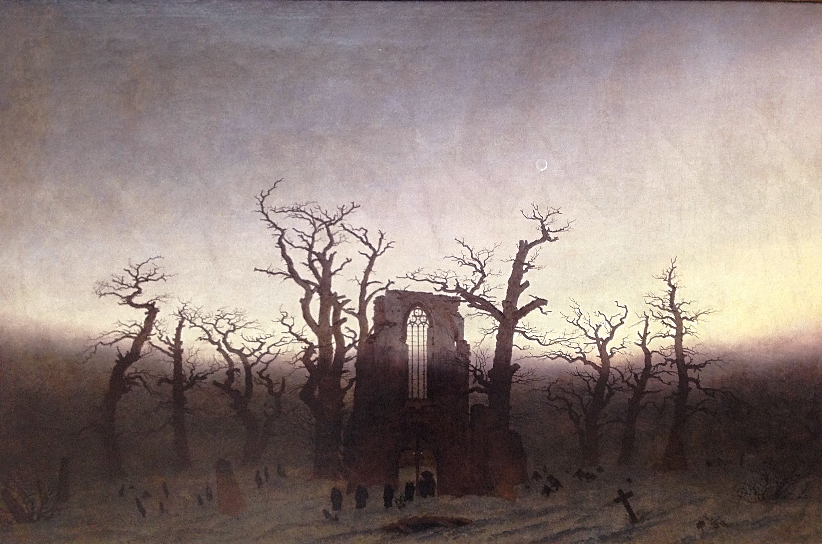
For reason of pure anti-clerical fervor, I presume, the church building itself was burned. Now all that remains is a ruined shell of a building. This is a shame, since was fragments that remains give some hint of a glorious medieval edifice. Some of the ornamental friezes around the doorways, for example, are of the finest quality. Now, however, the building’s appeal is Romantic rather than Romanesque. As I’ve mentioned elsewhere, ruins have a strange power to evoke feelings of mysterious awe. Certainly I felt this as I sat facing the destroyed altar, the walls reaching up to a vacant ceiling, the sky gaping overhead. It was like stepping into one of Caspar David Friedrich’s paintings—a timeless, fossilized wreck.
If the burnt church building is unintentionally romantic, the rest of the monastery is quite intentionally so. After briefly being owned by a wealthy Catalan merchant, who mainly used it for agriculture, it passed into the hands of Juan Federico Muntadas.
A well-educated and original man—among other things, he created the first fish farm in Spain—Muntadas was born in 1826, and was thus roughly of the same generation as Gustavo Adolfo Bécquer. And, like Bécquer, he was a Romantic. If you, for example, compare the royal gardens of Aranjuez or La Granja with Muntadas’s creation in the Monasterio de Piedra, you can get some idea of the mental difference between the Enlightenment and the Romantics. Whereas the royal gardens are neat, orderly, symmetrical, with clearly delineated plots for plants and paths for people, Muntadas molded a space that creates the sensation—if not exactly the illusion—of untrammeled nature.
The walking path through the monastery grounds takes about an hour. Though it was winter, the place was still quite green. Shallow ponds reflected the twisted and bare forms of tree limbs, while the verdant underbrush was speckled with the reds of crinkled fallen leaves. Small wooden bridges led the walker through this marshy area to the main attraction: the waterfalls.
Using the diverted waters of the Piedra and the Ortiz, Muntadas created a dazzling series of cascades. Varying in size from ankle-level to the size of an apartment building, these waterfalls are some of the prettiest I have ever seen. The rocks have been carefully placed to divide the stream into several rivulets, creating a dancing pattern of sparkling, splashing streams.
The path took me up beside one of the larger waterfalls and up a staircase in the adjacent rock face. Ivy, branches, and leaves were draped around the water, as if thirsty for a drink. Once at the top, we passed over a shallow stream, and followed it down again as it accelerated into a whooshing, multi-layered cataract, the stairwell winding its way downwards beside the water. Children and parents were crowded on the slippery steps, posing for photos. Along the way I caught a glimpse of the surrounding area, whose red rocky cliffs and rolling hills stretched into the far distance. The path continued, becoming narrow as it navigated the hillside, until finally we were led into a cave.
This cave—full of stalactites and stalagmites, green with algae, the jagged rock edges worn into eerie undulations by the water—was under the largest of the waterfalls. Water poured down at its entrance, filling the place with a ceaseless mist. I had to take off my glasses since they got so covered in droplets. We came out of the cave the same way we went in; then, after a walk through a long tunnel, I found myself by the famous Lago del Espejo, or Mirror Lake.
The shallow water, only inches deep and filled with aquatic plants, was uncannily reflective. And there was plenty to reflect, since the lake is situated underneath impressive rock faces, stretching up far above us and casting imposing shadows. By this time I had completely fallen under the spell of the place. The impression created by so many manipulations of water and stone was that of deep, almost meditative calm. I felt perfectly relaxed and refreshed.
Finally I ended up where I had begun: by the old, burnt church. Quite hungry by now, I went to the restaurant near the visitor’s center, which had quite a good—and affordable—daily menu. Then, stuffed and exhausted, I boarded the bus to go back to Zaragoza.
Remote and difficult to get to using public transportation, El Monasterio de Piedra is yet another example of Spain’s seemingly inexhaustible treasures.
In the center of the province of Aragon, on the banks of the second longest river in the Iberian Peninsula, the river Ebro, sits the city of Zaragoza. (In Spain, the name is pronounced “Tharagotha.”) The fifth largest city in the country, Zaragoza is comparatively ignored by tourists. Yet the city is well worth a visit. Populated since Roman times, conquered and ruled by the famous warrior, El Cid, and then governed by the Muslim Almoravids until reconquered by Alfonso I, the city has a long and important role in Spanish history.
But all I knew about the place, when I visited, was that it is relatively cheap and relatively close to Madrid. So one puente (a long weekend) in December, I decided to explore the city.
§
The drive to Zaragoza took us through Soria—“the ugliest part of Spain,” said the driver of my blablacar, who didn’t like the Martian red soil of the province (I disagreed). Zaragoza itself is situated betwixt several mountains, which protect the city from rain but do not shield it from the mist that drifts down during winter. The city huddles around both banks of the Ebro, a wide and powerful river that is periodically spanned by low-lying bridges, connecting both halves of the city.
I arrived fairly late in the day. The city was chilly, a fog hung about the air, some snow had recently fallen but little remained. My Airbnb host recommended a nearby walking path. I took her advice, having more than enough time to explore the city later. This path was called La Alfranca, and quickly led me outside the city and into the fields beyond, following the course of the Ebro going southeast.
This was my first trip alone in Spain. I enjoyed the solitude and the silence of the countryside. The skeletal forms of winter trees, arranged in neat rows, bisected fields of wheat. A lonely man in a tractor dug up a field. Joggers went by occasionally, but for the most part I was alone on the path. La Alfranca stretches 15 kilometers in total but I decided to turn back long before that, returning on the opposite bank of the Ebro.
Walking on in this way, I came back to the city. Eventually the magnificent form of Zaragoza’s famous basilica, Nuestra Señora de Pilar, rose up on the other side of the river, its four towers lit up from underneath with a pale yellow glow. I crossed over the Puente de Piedra, the oldest standing bridge in Zaragoza, which leads directly to the basilica. The design of this bridge is very similar to the Roman bridges that can be found in Spain, such as in Mérida or Córoba or Salamanca, but it was built in 1440, long after the Romans. There was, indeed, a Roman bridge that used to span the Ebro near that spot, but it was destroyed in the ninth century.
El Pilar
I found my way to the Plaza de Pilar, Zaragoza’s central square, which stands in front of the basilica. The place was bustling with life. A Christmas market, selling nativity figurines and specialty foods, surrounded the periphery. In the middle was a life-sized nativity display, fenced off, which you had to pay to enter; there was a long line of eager families waiting. On one end of the square was a skating rink, full of people slipping and circling, and on the other side there was a large artificial hill where children and adolescents could ride down on inflatable red sleds.
Kids sledding, with Le Seo behind
I went up to the food stand and ordered “hot wine,” which was warm and sweet, the perfect winter drink, and then I decided to eat dinner there. As I ate, the sound of music attracted my ears. A band, playing a fusion of traditional and rock music, was on stage performing; an accordion and a mandolin player supplemented the usual rock trio. I quite liked it. I stayed to watch the whole performance, and later, when it finished, a big group of amateur flamenco musicians set up chairs below the stage and began to sing and play. I must say I love encountering flamenco in this way, as a genuine part of daily life here in Spain. It is such a raw and gripping music, at once dramatic and unpretentious.
This was my first day in Zaragoza, a lovely walk followed by a lovely encounter with community life in the city. Already I had decided that I quite liked it here.
§
Day two. Now it was time to explore the city’s monuments. My first stop was, of course, Nuestra Señora de Pilar.
The basilica gets its name from a legend. Saint James the Greater was in Spain, attempting to convert the (then Roman) citizens to Christianity. Dispirited by failure, he began to pray at the banks of the Ebro, and the Virgin Mary appeared to him in a vision, holding in her hand a column of jasper. According to tradition, James then established a small chapel in Spain—the first ever church dedicated to the Virgin Mary. In the center of the beautiful main altar is a small wooden statue of Mary standing atop a small jasper pillar, believed to have been given to James by Mary’s accompanying angles.
One need not believe this story to believe that the basilica has an impressively long history. After Christianity was legalized in the Roman Empire and eventually made the state religion under Constantine, a basilica was built on the spot. This basilica subsequently underwent all the stylistic changes of Spanish history: Romanesque, Gothic, Mudéjar. In the fifteenth century a fire gutted and damaged the previous building; and thus the current edifice mostly owes its shape to the Baroque. Four high towers stand on each corner of the cathedral; a central dome, not quite as tall as the towers, is flanked by several smaller cupolas. The result is undeniably magnificent, giving the impression of tremendous size and elegant design.
The interior is equally grand, with white walls and long naves, flanked by rounded arches and topped with cupolas that let in the daylight. The decoration has none of that excess or horror vacui commonly associated with Baroque; rather the friezes and moldings are neoclassical in their symmetry and restraint. The floor-plan of the building is not a crucifix, but a grid, with several impressive altars nestled in different chapels.
When I entered, mass was being held in one of these, the Chapel of the Virgin. The priest stood before a statue of Mary, as she is carried up to heaven on a cloud, surrounded by a halo of golden sunlight. Along with El Transparente in the Cathedral of Toledo, this whole chapel, by Ventura Rodríguez, is one of the masterpieces of Spanish Baroque, clearly bearing the influence of Bernini.
The insides of the cupolas are decorated with colorful frescos showing scenes of heaven. A young Francisco de Goya was one of the painters who worked on these, though to my ignorant eyes his fresco does not have any of the distinctive marks of his later style. Among this embarrassment of riches, my favorite work was the main altarpiece, a colossal and stunningly intricate carving in alabaster. It is this altar that holds the legendary statue of the Virgin. My mind boggles as I contemplate the amount of time it would take to carve something so big and so finely detailed. One would think a lifetime would be needed for such a task; but the sculptor Damián Forment did it in just six years, from 1512 to 1518, mixing late Gothic and early Renaissance elements in the style.
El Pilar main altar
My next stop was Zaragoza’s cathedral, La Seo. Its real name is the Catedral del Salvador, but it is commonly call “La Seo” (Spanish for “Episcopal see”) to differentiate it from El Pilar. Somewhat unusually, Zaragoza doesn’t have one cathedral; instead El Pilar and La Seo share co-cathedral status.
La Seo
From the outside La Seo is nothing compared with El Pilar. Indeed for a cathedral it is quite diminutive and inconspicuous. This is not to say that it is unattractive. The main entrance is, admittedly, adorned with a somewhat bland neoclassical façade; but the campanile is really lovely, an elegant Baroque structure whose tan outline cleaved the foggy sky. I particularly liked the floating angels who hold up the central clock. On the other side of the building you will be surprised to find a mudéjar exterior, complete with geometrical patterns and six-pointed stars. About one thousand years ago, a mosque occupied this spot; and the influence of the Moors can be seen still.
Mudéjar exterior of La Seo. Photo by ecelan, taken from Wikipedia Commons
This stylistic jumble is a foretaste of what the visitor encounters on the interior. I still feel bitter that I was prevented from taking photos—I don’t know why some monuments prohibit them and others do not—since the chapels in La Seo are some of the most ornate and stunning that I have ever laid eyes upon.
Every chapel is in a world unto itself. Each one is executed in a different style. On the pillars and walls surrounding some were friezes of almost nauseating detail, full of vegetable patterns and gruesome figures, bodies and vines woven around one another in an intricate tapestry (this is called Churrigueresque). Not every chapel was so lavish; other were neat, orderly, and harmonious, and no less visually pleasing. I found myself staring in wonderment, spending a long time at each chapel, doing my best to disentangle the layers of images and commit the chapels to memory.
Considering that the visitor can find examples of so many different styles—Romanesque, Gothic, Mudéjar, Baroque, Churrigueresque, Plateresque, Aragonese Renaissance, and Neoclassical—La Seo is a veritable history of Spanish architecture in miniature. Its interior is just as impressive as the exterior of El Pilar.
My last stop was the Aljafería. This is the Alhambra of the north, a fortified castle that contains a Moorish interior. From the outside it is an imposing military edifice, complete with a moat (empty of water) and high walls. Though impressively massive, there is little to distinguish these walls, in my eyes, from other castles I’ve seen, except for a few horseshoe arches.
But this is far from true of the interior of the palace. Here you will find the greatest example of architecture from the Taifa period of Moorish Spain. This was the period after the fall of the Caliphate in Córdoba (1031), when power in the peninsula was highly decentralized, divided into many small “Taifa” kingdoms. The palace within the walls was mostly constructed between 1065 and 1081, under the auspices of Abú Yafar Al-Muqtadir.
This palace is the most magnificent example from this period in Spain’s history, and each room merits deep study. Unfortunately my ignorance only allowed me to gape with admiration as I walked through, appreciating much but understanding little.
One thing I did notice was that most of the arches were not the typical horseshoe shape I had come to associate with Moorish architecture. Instead, they are pointed arches, with a series of miniature arcs that provide ornamentation. (I believe the technical name is “mixtilinear arch.”) As is typical in Moorish and Mudéjar architecture, intricate stucco-work decorated the walls with fancy geometrical patterns and exotic arabesques; and the ceilings are the elaborate wooden type I have seen in many buildings across Spain. All of these features can be seen in the Golden Hall, the former throne room. Also characteristic was the garden courtyard, a cool interior space adorned with symmetrically arranged plants: this is the Patio de Santa Isabel, named after Isabel, canonized queen of Portugal (1282 – 1325), who was born in the Aljafería.
After inspecting this lovely space, I ascended some stairs and found myself in an entirely different world. This is the adjoining palace of Peter IV of Aragon, a Christian king of the 14th century. (Christians had conquered Zaragoza in 1118.) Though aesthetically quite different—closed spaces as opposed to open-air, for one thing—this palace is quite as lovely as the original, mixing Gothic and Mudéjar styles into a distinctly Spanish combination. The most impressive room is, as usual, the throne room, which is covered with a brilliant coffered ceiling—complete with six-pointed stars and hanging golden pine cones. This is a style of decoration called artesonado, heavily influenced by Moorish precedent and employed in many buildings in Spain.
The ceiling of the throne room.
As you can see, the Aljafería has served as the seat of power for Muslim and Christian rulers alike. And it continues that function today, as the home of the Cortes of Aragón, the province’s regional government. Considering the huge lines that often attend visiting the famous Moorish monuments of the south—the Alhambra, the Alcázar, the Mezquita—I would say that the Aljafería is well worth your time, since there was no line at all.
Now it was lunch time, and I’m afraid my story takes on a farcical tone at this point. I was feeling somewhat lonely, and what’s more I wanted to treat myself, since it was my first trip of the school year. So I went to Zaragoza’s famous eating neighborhood, a street called El Tubo, and found a mall that had an Arrocería (a paella restaurant). I ordered myself paella and some patatas bravas—fried potatoes covered in a mild sauce. But I found that this was far more food than I anticipated. The quantity of potatoes was obviously meant for two people. But I was treating myself, so I decided that I would overeat and try to finish them all. Despite my typically American ability to stuff myself, I couldn’t quite do it; my stomach was full to bursting. After that, I went to get a coffee and cookies.
A giant plastic statue of Caesar Augustus, wishing you Merry Christmas
Uncomfortably bloated and feeling a little sick, I waddled my way to my next stop: the Museo Pablo Gargallo. I actually had no idea what this was, and only went because of its high rating on Trip Advisor—such is modern tourism. Pablo Gargallo (1881 – 1934), it turns out, was one of the greatest sculptors of twentieth century Spain; and his museum, much like the Musée Rodin in Paris, is a grand collection of his works in an attractive historical building (in this case, a former palace).
Gargallo’s style wavered between classicism and modernism, combing traditional and cubist elements. His most famous work, El Profeta, is an excellent example of this: a moving mixture of Picasso and the Old Testament. (There’s a copy of this work in the Reina Sofia.)
But I was in no mood to deeply analyze his work. I was in pain. My stomach felt like it was filled with lead. Bullets of sweat were dripping down my back. Meanwhile, I was faced with an odd assortment of grotesque statues—twisted bodies, fragmented faces, simplified expressions—and I couldn’t help feeling unnerved, as if my suffering was somehow manifest in this museum.
Finally the pain got so bad I had to sit down. I unbuckled my belt and sat back, breathing hard. I couldn’t fool myself any longer: my day was over. When the agony abated somewhat, I got to my feet and left the museum. I was going back to my Airbnb; and since I wasn’t familiar with the public transportation system, I had to walk. So, clutching my belly, I slowly made my way through the winter streets, pausing now and then to recover myself.
About ten minutes into the walk I began to gag. Stomach acid scorched my throat as I choked it down. I knew it would feel good to just empty my innards; but I was surrounded by people and mortified by the possibility of vomiting in broad daylight. The gagging came stronger, I resisted, and it came stronger still. I was determined not to throw up; my belly had the opposite idea. Finally, after a heroic effort, I forced down an eruption. Suddenly the pressure let off; I thought I was in the clear. But then without warning it all came rumbling up, and I emptied my insides all over the street, my shoes, my scarf, and my coat. I was covered in it.
I looked bad, and smelled worse. I began to walk at full speed, keeping my eyes on the ground, determined not to make eye contact with anyone on the street. I still had a ten-minute walk ahead of me. I couldn’t even handle my phone since my hands were sticky and wet. Those minutes passed like hours. My adrenaline was pumping like mad, filling me with a nervous excitement, my fight-or-flight response temporarily suppressing my embarrassment and my disgust.
Finally I got to the apartment. I rushed up the stairs, nearly fell into the bathroom, and threw all my clothes into the shower. After an hour of frantic cleaning, I went wearily to my room, dwelling on my miserable condition.
So ended my trip to Zaragoza. Despite my mishap, I was extremely impressed. The next day I was going to Zaragoza’s famous nature preserve, El Monasterio de Piedra. But that’s for another post.
(I decided to split my original post for ease of navigation. Continued from part one.)
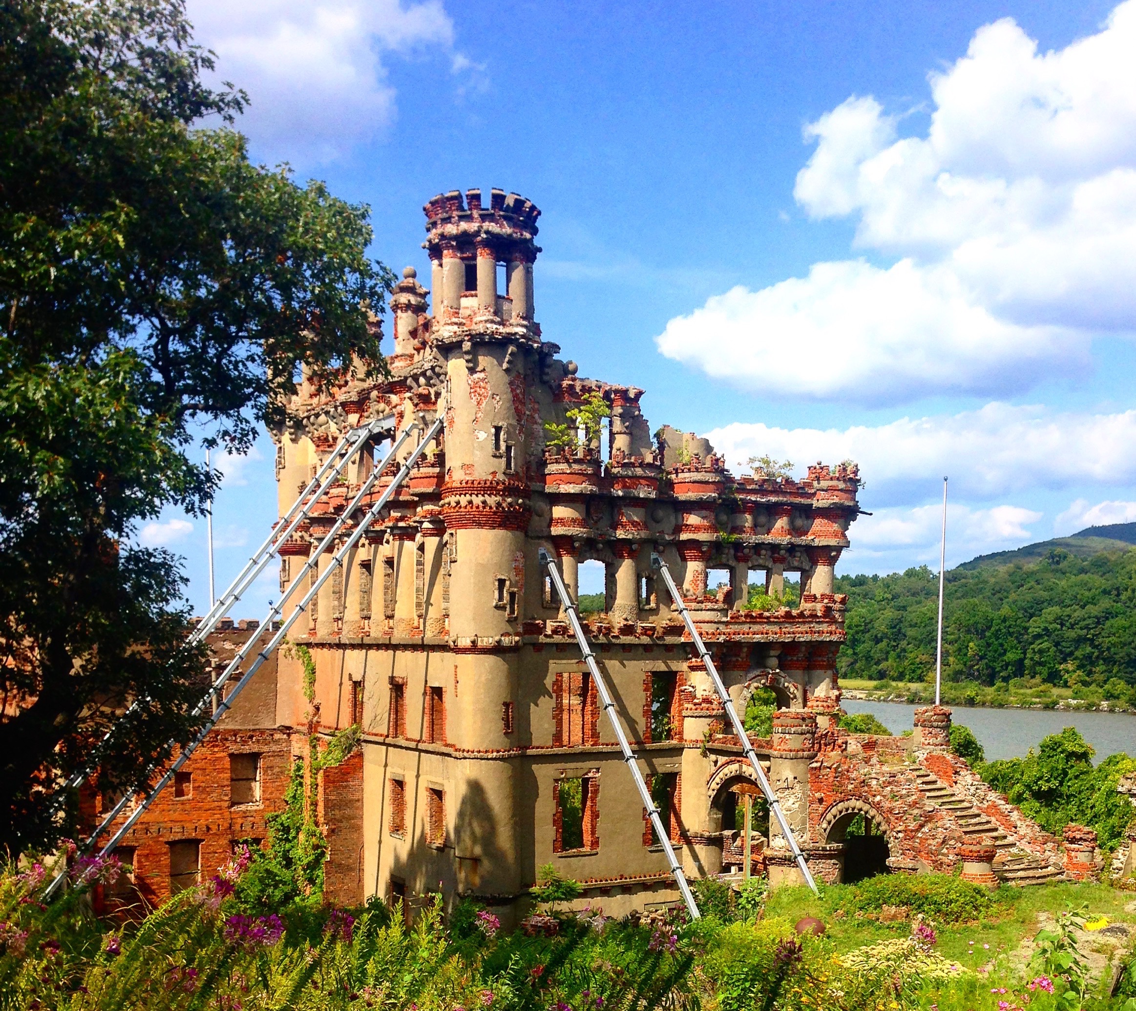
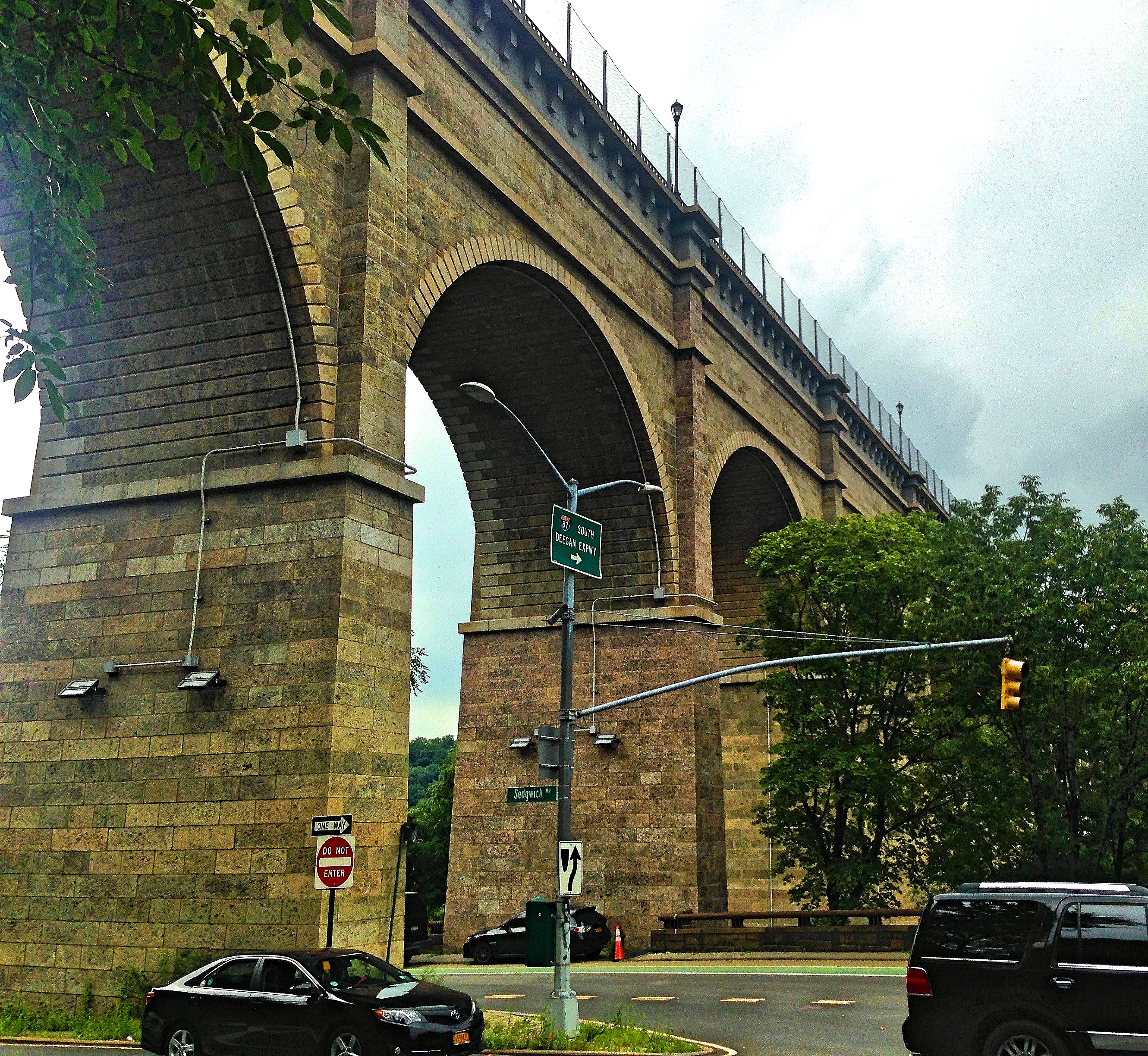
Further north in the Hudson, as the train passes through the marshes at Cold Spring and then hooks along the edge of Hudson Highland Park on its way to Beacon, the passenger will see something striking through the window. Standing on an island in the Hudson, conspicuous and incongruous, is a castle.
Or perhaps I should say a former castle, since it is distinctly a ruin now. Only the outer walls remain, its insides gutted and empty. Ivy climbs up the surface and the green shade of trees can be seen through the empty window frames. Even so, it is an impressive sight, with its battlements and crenellated walls standing proudly over the Hudson, like something out of a fairy tale.
But it is clear, upon reflection, that this structure could never have been an actual castle, despite appearances to the contrary. Putting all tactical considerations aside—castles were obsolete during almost all of our history—its brick walls are thin and high, totally unsuited to defensive architecture. (To see what I mean, visit Castle Clinton in Battery Park, which has thick, squat walls, durable and difficult to hit with canon fire.)
Like many passengers on the train, I idly wondered “What is that?” as we passed, my mind drifting off to remote possibilities. When I asked my mom later, she told me that it was built by a rich American with a European wife, who wanted to make her feel at home in the New World—or at least, that’s the story she heard. I was satisfied with this rumored explanation for a time. But upon my return from Spain, I decided to dig a little deeper into the castle’s history. And, as so often happens, the truth is far more interesting than the myths.
Unless you have a boat and don’t mind being penalized for trespassing, the way to visit the castle is on a tour with the Bannerman Castle Trust. These tours depart from either Newburgh or Beacon, two historic towns that are themselves worth visiting. You can choose to go by ferry or kayak. (In a recent homicide case, which made national headlines, a woman was convicted for criminally negligent homicide when she left her fiancé to die in the Hudson after his kayak capsized near Bannerman Island. I took the ferry.)
Our tour left at two in the afternoon. About forty people lined up at the water, and then crossed a wobbly dock to board the ferry. As I said, the tours are given by Bannerman Castle Trust, the same organization that is responsible for the castle’s preservation. They are a genial and jovial bunch who obviously enjoy what they do.
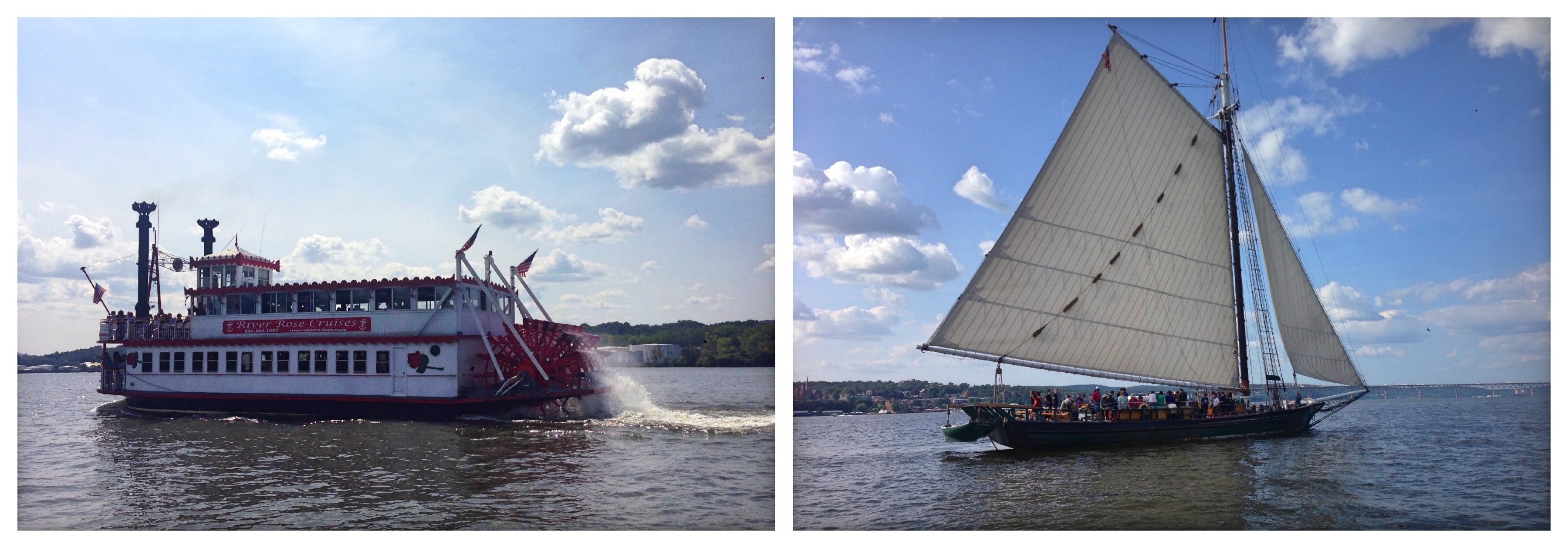
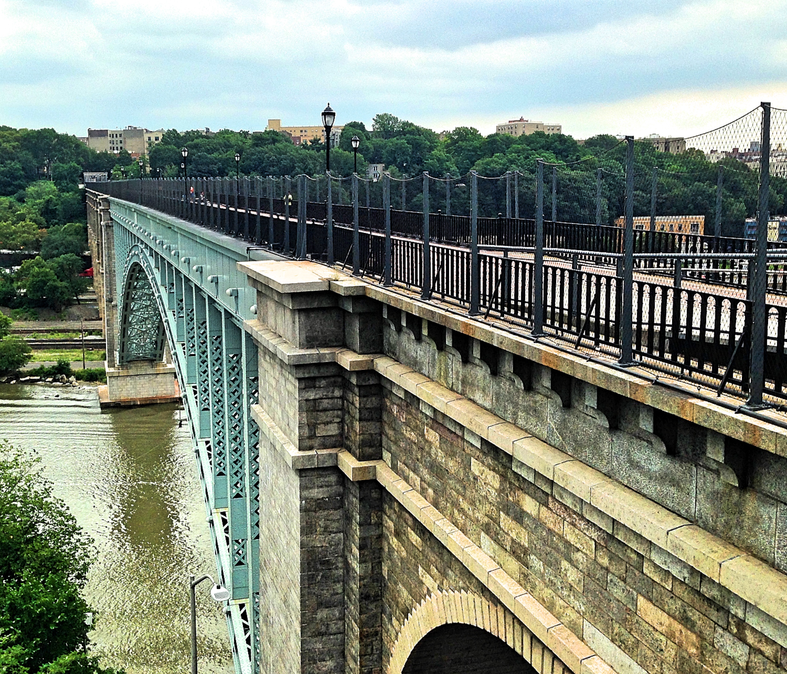
The boat began its short journey to the island. To our left we could see the Newburgh-Beacon bridge, a surprisingly pretty cantilevered steel construction. It was a sunny day and the river was full of boats. Jet skis and cigarette boats zoomed past, making a terrible racket, and kayakers waded in the shallows. Along the way, we passed two antique vessels, a Mississippi paddle wheeler and a sail sloop, and all the passengers waved to each other—people are generally friendlier at sea, I suppose. (The sloop was the Clearwater, the boat built as part of Pete Seeger’s campaign to clean the Hudson.)
The River Rose and the Clearwater
The castle seemed to rise out of the sea as we neared. By its juxtaposition, the Hudson Valley was transformed into an alpine lake or a Scottish loch in my eyes. We docked and shuffled out, and the tour guides split us into two groups. Thus commenced an excellent two-hour tour, which explained a history that was far more interesting than I dared hope.
Though commonly known as Bannerman Island, its true name is Pollepel Island. ‘Pollepel’ is one of those place-names that baffle explanation. Our guide told us that his preferred hypothesis was that the island was named after the Dutch word for a wooden spoon, which was also the name for the contraption that deposited misbehaving sailors on the island as punishment. There is also a legend about a girl named Polly Pell, who was stranded on the island and rescued by a brave lad, who she then married—a story which, like all tales of romance, our guide assured us is baseless and false.
In any case, the really interesting history of the island begins in 1900, when it was purchased by Francis Bannerman VI (1851 – 1918).
Bannerman has one of those appealing, Andrew Carnegie, rags-to-riches stories from the nineteenth century. Like Carnegie, Bannerman came to the United States from Scotland, a poor boy in a poor family. After a series of odd jobs, his father ended up in the scrap industry. Then, when the Civil War broke out, Bannerman’s father went to fight for the Union side, forcing the younger Bannerman to quit school and work for the family business. At night, he made extra money by traveling around the New York harbor in a little rowboat, using a hook to dredge up chains and rope that ships had sloughed off into the water, in order to sell them for scrap.
Later, the younger Bannerman started his own scrap company. He found a profitable—and at the time entirely novel—avenue for business in selling old military equipment. You see, after a war is concluded, all sorts of goods—rifles, swords, bayonets, canons, black powder, uniforms, and even canned foods—can be purchased very cheaply. Then, when another war breaks out, it can be sold at lower prices than new equipment, while still making a nice profit. Bannerman didn’t only sell to bellicose governments, however, but became a leading supplier to collectors, bands, vaudeville acts, rodeos, movie producers, circuses, and theater groups. Bannerman’s illustrated catalogue are still regarded as the gold standard by collectors of antique war equipment.
After doing business in several different locations in Brooklyn, Bannerman opened his main shop in Manhattan, at 501 Broadway. But the city government very sensibly decided that it was unsafe to have so much military equipment, including several tons of explosives, in the middle of a major city; so they made him move it out. This is why Bannerman purchased Pollepel island for his armory—it is isolated and therefore safe. The location had another advantage. Since the island is in full view of the train, and since the Hudson, at that time, was crawling with merchant ships, Pollepel was an excellent place to advertise his business from. Hundreds of potential customers would be passing by each day. This is also why Bannerman invested in such ornate architecture. A castle is certainly more eye-catching than a billboard.
Bannerman died in 1918, of “overwork,” as the New York Timesobituary said, using one of those euphemisms of the previous era. At the time, he was donating large amounts of equipment to the Allies fighting the First World War. His business model became seriously compromised a few years earlier, when a change in the laws imposed stricter regulations on the trading of explosives—which is good news for the rest of us.
If Bannerman had lived two years more, he would have seen the wisdom of the New York City government in banishing him to the island. For in 1920, one of the powder houses blew up. It was a massive explosion, reportedly breaking windows for miles in all directions—or so said our guide—and blowing a chunk of the wall hundreds of feet across the Hudson onto the train tracks, blocking the train for hours. Bannerman’s wife, Helen, narrowly avoided death (the hammock she had been laying on was hit by flying debris, but she had just gone inside), and her eardrums were ruptured by the shockwave.
Under the direction of Bannerman’s sons, the business carried on for a time, until eventually, in 1967, the island was purchased by the State of New York for parkland. Despite the family’s attempts to sell off their massive store of supplies, there was still much left, some of which was taken by the Smithsonian Museum. The island was opened to the public the next year. But then the next phase of damage to the island occurred. In 1969, the buildings caught fire in a colossal blaze, perhaps an act of arson, destroying everything except the outer brick and concrete walls. After that the island was off limits to the public, for the sensible reason that the remaining structures were unstable and could collapse.
Many years later, in 1993, the Bannerman Castle Trust was founded, which worked with the State of New York to preserve and promote the castle. They have made great strides. Kayak tours, hard-hat tours, and finally, in 2003, walking tours were introduced. The dock where the ferry lands and the stairway that leads up to the island were built under their direction, as was a bridge connecting the two highest peaks of the island (which cadets in West Point helped to construct). They also organize volunteer teams of gardeners, who have created some really splendid gardens on the island. And this is not to mention the historical work.
Thankfully, nobody was hurt when, in 2009, a big section of the outer walls collapsed. To prevent further damage, the walls are held up by long metal braces. Still, it’s worth asking how much longer the structure will last without substantial repairs.
Despite the explosion, the fire, and the collapse—and partially because of them—the castle is magnificent. For me it was a dreamlike experience to be standing near it, since I have been fantasizing about visiting this island since I first laid eyes on the ruin. The façade of the building has many charming architectural ornaments, such as the semispherical balls that run along the top. A resourceful man, Bannerman used vintage bayonets to reinforce the concrete.
The castle isn’t the only structure on the island. On the second highest point—Bannerman was afraid of lightning strikes, so he didn’t build on the highest—is the house in which he and his family stayed. This building was only very recently rehabilitated; only a few years ago, it was covered in ivy. The house is built in the same vein as the castle, a fanciful exterior concealing a homey interior. Now it is a sort of mini-museum, full of old images and informational panels.
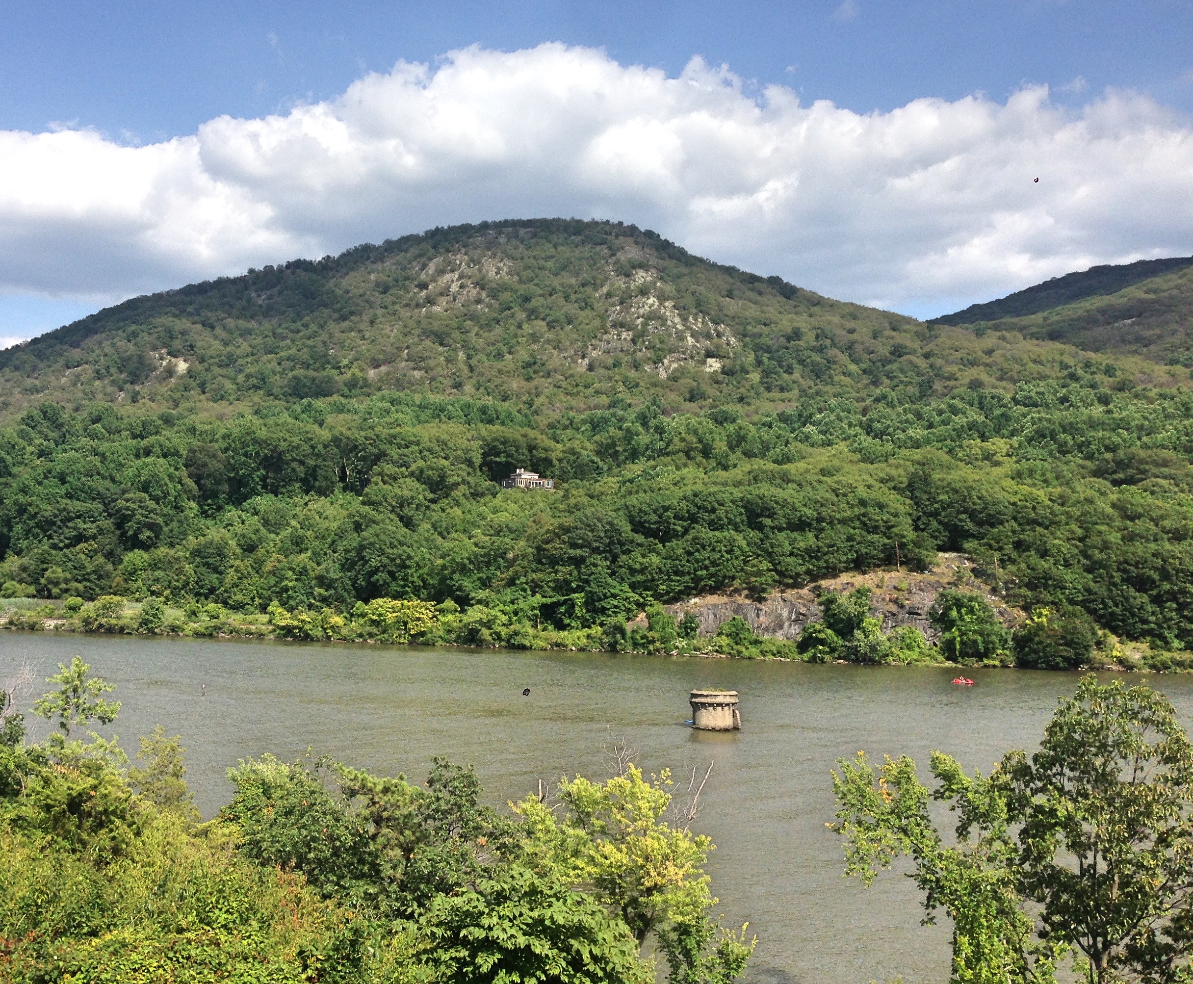
In the water surrounding the island, there are still further remnants of Bannerman’s business. During the island’s heyday, Bannerman constructed an artificial harbor, or breakwater, around the island. Now only a few stone towers remain, peaking out of the water. Doubtless more are submerged just under the waves, a hazard for passing boats.
One of the old towers for the breakwater
The Bannermans only stayed on the island during summers. But a superintendent, Leonard Owen, stayed all year long; and his daughter, Eleanor, grew up on the island, commuting to school by sled during winter. Two of the historians of the island, Barbara and Wesley Gottlock, recently turned her memoirs into a children’s book. (These two authors also collaborated on the Images of America book on the island, which I relied on for this post.) Bannerman’s daughter, Jane, is still alive and active in the Trust.
Well that’s the story, or at least the quick version. When I began learning about these ruins, I had no idea that they would contain so much history. Perhaps I should stop being so surprised that the world, once examined, is a tremendously interesting place. Ruins are not just food for the imagination. Every ruin, even the humblest, is the product of human hands, and bears the traces of humans dreams and disappointments.
(I have broken up my original post into two separate posts, for ease of navigation. You can find part two here.)
Introduction
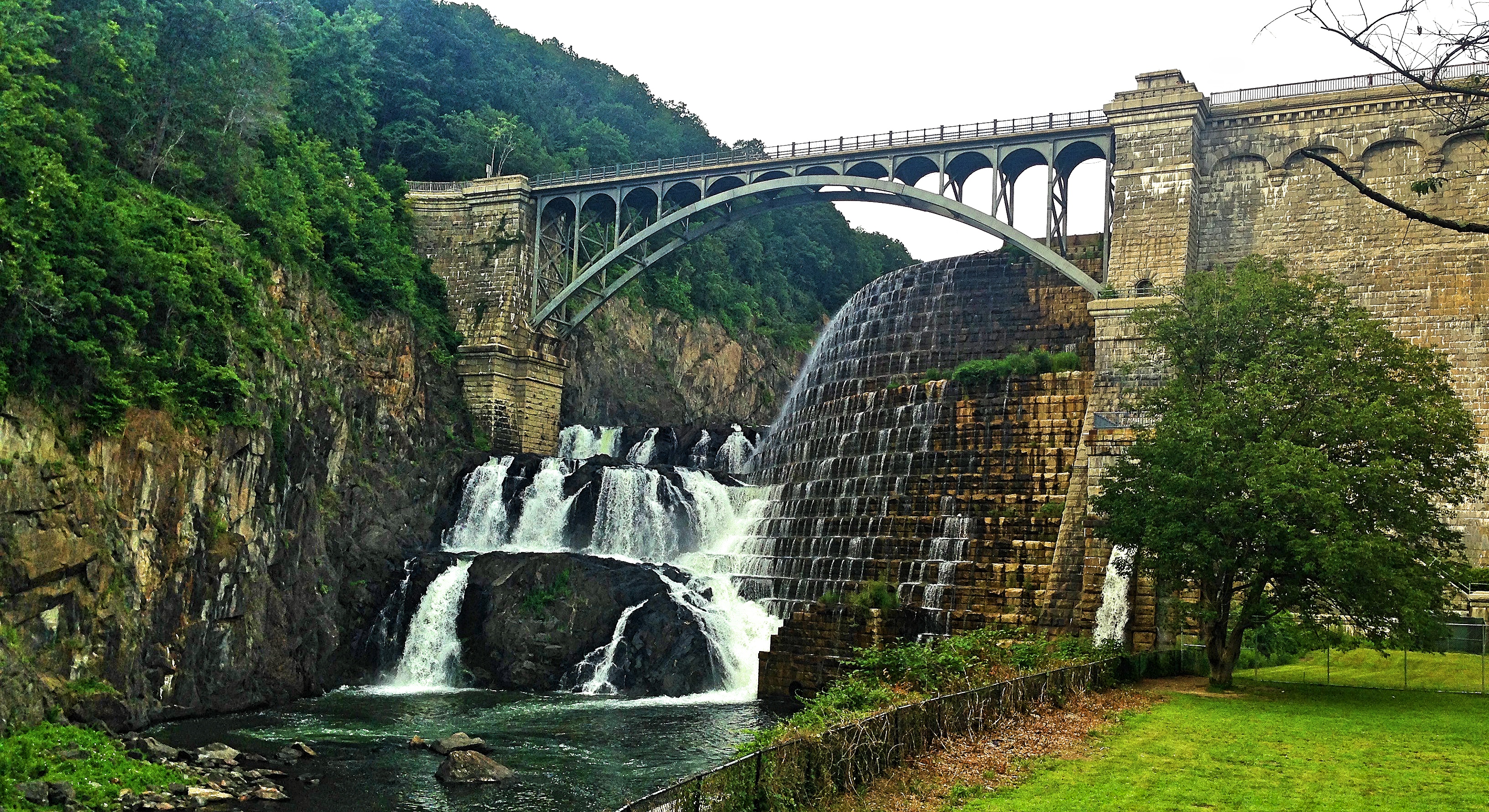
The train ride on the Hudson Line, from Manhattan to Poughkeepsie, must be one of the most scenic in the United States. The ride has both natural and artificial beauties along the way. The Hudson Valley itself is magnificent, with the palisades across the shimmering waters; and this is doubly true in autumn, when the trees turn their fiery hues. Occasionally you pass a sail boat or a freight barge in the river, or a team of rowers diligently practicing in the Bronx. The train also takes you under the High Bridge, the new Tappan Zee Bridge, and the Bear Mountain Bridge, three engineering feats. A careful rider can even catch a glimpse of Sunnyside, Washington Irving’s old home. (Irving was very annoyed when they built the railroad right next to his house.)
Hudson Palisades
Among all this, the most striking landmarks along the way are, for me, the ruins. Specifically, two ruins: the Yonkers Power Plant and Bannerman Castle.
Ruins have a power to fascinate that is difficult to account for logically. They are the same structures that exist, in unruined form, all over the place. The difference between a ruin and a proper structure, architecturally speaking, is pure defect: the ruins have lost their integrity and utility. And yet ruins have been captivating the artistic imagination since at least the Romantic era. Their battered and broken forms have provided inspiration for Shelley’s poems, Byron’s travel sketches, and Caspar David Friedrich’s paintings. It was the ruins of Rome that shaped the Renaissance in Italy, and those same ruins that inspired Edward Gibbon to memorialize Rome’s decline and fall.
What is it about ruins that is so compelling? There are many answers. One is that ruins allow us to visualize time. We see how time’s tooth rusts metal, cracks foundations, and crumbles stone. We see what rots away and what petrifies in place. Ruins also allow us catch a glimpse of a world without humans, the world we would leave behind if we all mysteriously disappeared. We can see the natural world slowly reclaiming buildings and walls, as plants and animals invade the empty space. Perhaps we feel what Shelley felt when contemplating the fate of Ozymandias: that humanity’s urge for immortality is futile and vain, since everything eventually decays.
For all of these reasons, and still others, ruins have an undeniable power—as attested by the many photographers, amateur and professional, who go out of their way to document them. This is my little contribution.
The Yonkers Power Plant
The Hudson Valley has been many things since its water began to carve a channel through the earth: wilderness, scenic escape, suburbia.
One hundred years ago, the valley was an artery of industrialization, dotted with factories and warehouses, noisy with barges and freight trains. The Hudson Valley was also one of the great centers of brick production, its soil baked and sold far and wide, which is why so many of its old buildings are brick. But we are long past the industrial age, and these buildings no longer house factories or store goods. Nowadays they house fine restaurants, cafés, or even libraries, such as the Irvington Public Library, which is in the old Lord and Burnham factory building.
The most impressive of these old factory buildings is still in use: the Domino Sugar Refinery, in Yonkers. Originally built in 1893, this refinery still produces three million pounds of sugar per day. It is one of Domino’s three major refineries, the last major sugar refinery in the Northeast, and a major source of employment within Yonkers. With an old, hulking brick building standing aside newer metal conveyer belts, this refinery is the sister of the more famous one in Williamsburg, Brooklyn, which closed in 2004 and was mostly demolished in 2014, except for some buildings given landmark status.
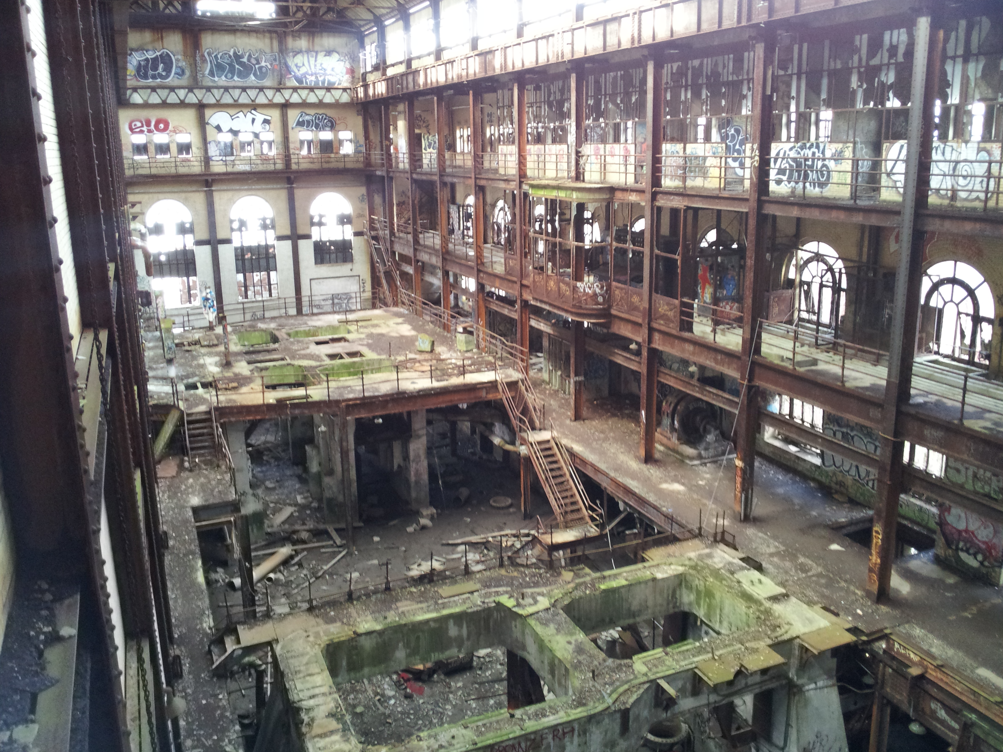
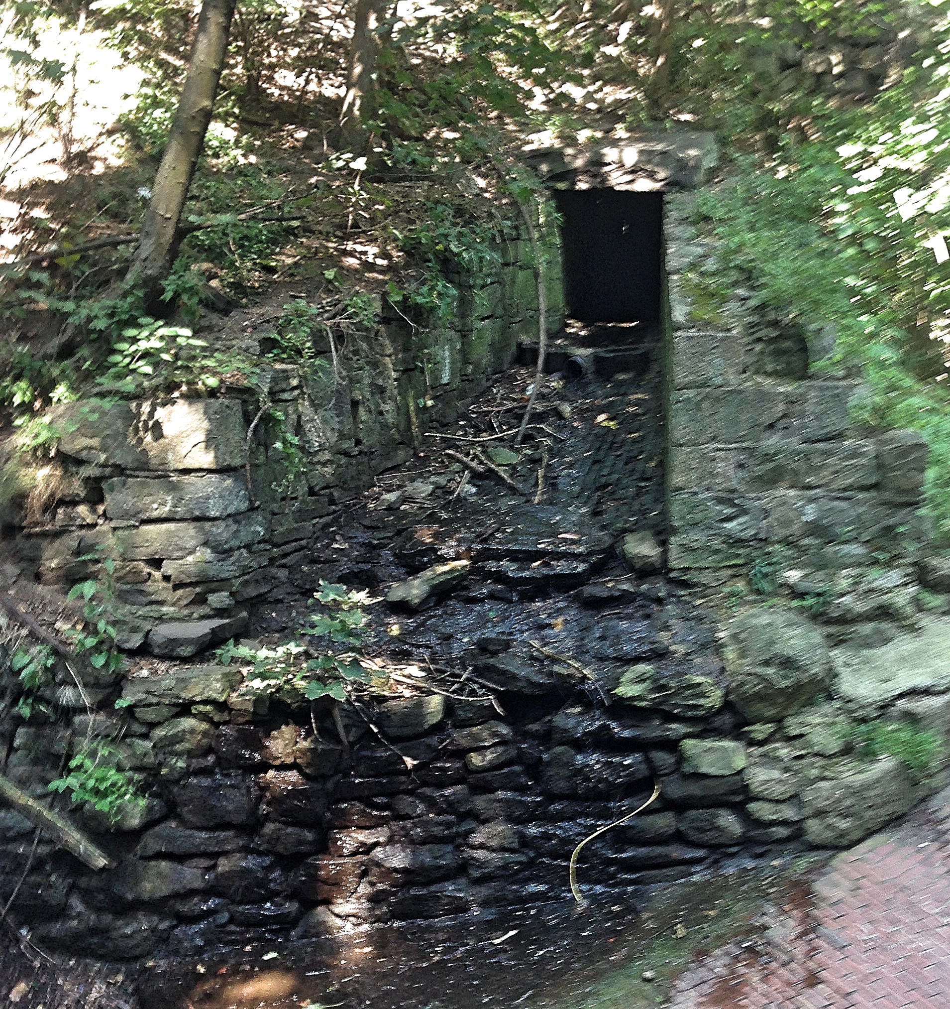
But the grandest ruin of the industrial age sits a few miles north. This is the Yonkers Power Plant, which stands on the river side of the local Glenwood train station. With its smokestacks scolding the sky hundreds of feet in the air, the plant is hard to miss. I often saw it on my commute to the city and wondered, what is it doing here? Why was there such a massive building rotting, empty and neglected, by the side of the tracks?
The answer comes down to power. When the trains began running in the 1840s—connecting faraway places and disturbing Washington Irving’s peace—they were running on steam. By the early 1900s, the railroad was prepared to switch to electricity, using the newly designed third rail. The problem was that, at the time, the municipal electrical grid was not powerful or dependable enough to supply the power. Thus the New York Central & Hudson River Railroad, which owned the Hudson Line back then, built their own power plants. The Yonkers Power Plant was situated along the river for several reasons: to be close to the tracks, to take advantage of the water to cool the machinery, and to make it easy to supply the plant with coal, which was delivered by ship.
The power plant was built by the architectural firm, Reed and Stem, who also collaborated on Grand Central Station. (Charles A. Reed was related by marriage to the president of the New York Central railroad, which doubtless helped him get commissions.) The plant opened in 1907, and ran on coal, which was brought by barge to the boiler room below. The steam generated by the boiler was used to power several massive turbines on the floor above. This power, generated in alternating current, was changed into direct current for the trains by rotary converters. (These rotary converters, by the way, are the only heavy machinery still in the factory; the rest was sold for scrap metal.)
Photo of the interior, by Brendan Jenkins, taken from Wikipedia Commons
By the 1930, it no longer made financial sense for the railroads to be in the power business, so in 1936 the plant was sold to Edison Light and Electric (a subsidiary of Con Edison) and converted to run on oil. This was not a long term solution either, since the plant’s relatively small size (relative to more modern power plants, that is) made it inadequate to New York’s massive power needs. So in 1963, the plant was closed. It was eventually sold to a private owner, who mostly let nature and teenagers have their way. The plant acquired the name “Gates of Hell,” for supposedly being the place where gangs held ritual inductions. Over the years, it became overgrown and covered in graffiti (some of it quite good). Meanwhile, proposals to transform the plant into apartments did not pan out.
(By the way, I am mainly relying on the excellent website, Hudson Valley Ruins, for this information. Their page on the power plant also has many great pictures.)
Most recently, the power plant was purchased by an entrepreneur named Lela Goren, who announced a plan to convert the plant into an arts exhibition center. The building will be renovated in two phases, which will cost $150 million all together, and finished sometime in the next decade. Work began in 2013. The grounds have already been substantially cleared of rubbish and debris, and the walls are being stabilized. I am pleased to learn, from this NY Times article, that Goren plans on keeping much of the industrial aesthetic, even the graffiti.
On a sunny summer afternoon I visited the plant for myself. I stepped off the train at Glenwood Station and craned my neck upward at the redbrick wreck. Despite the work the Goren Group had already done, the place is still visibly a ruin. All the windows are smashed; ivy climbs up iron beams; and an eerie silence pervades the building.
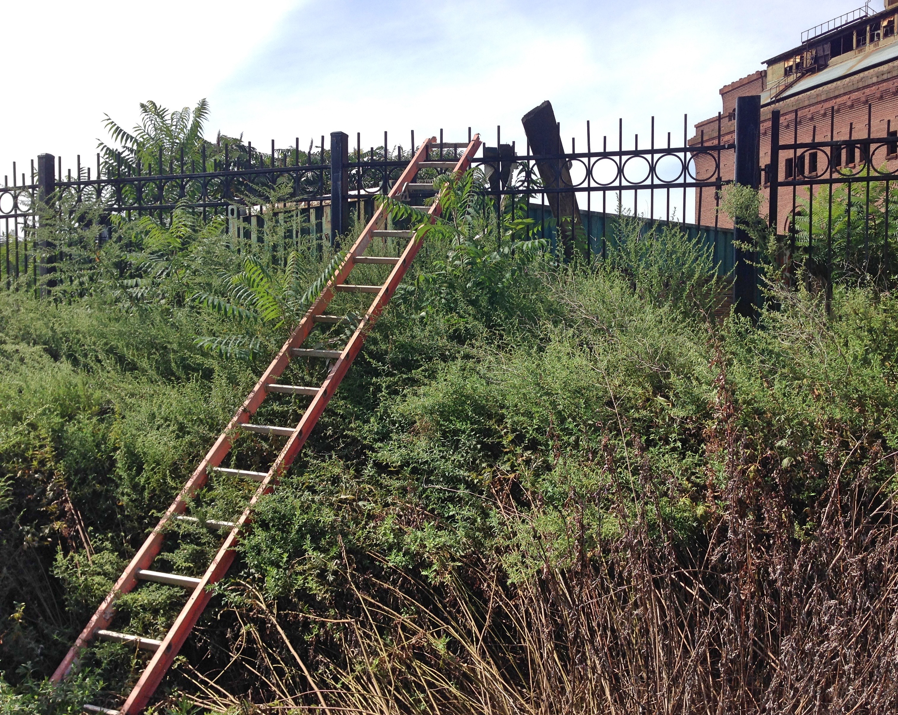
Glenwood is a local station, and few people use it. Aside from the old plant, Glenwood’s main attraction is the Hudson River Museum, which focuses on the river’s ecology. That day, I was the only person standing on the platform. A fence surrounds the old plant, covered in “Do Not Enter” and “No Trespassing” signs, assuring the prospective intruder that video cameras are surveilling the property. Even so, standing there alone on the platform, with nobody else in sight, it was difficult to resist climbing into the ruin. I would not even have had to climb the fence, since a stepladder was helpfully leaned up against it. The ruin still has its visitors.
Ladder still used by trespassers
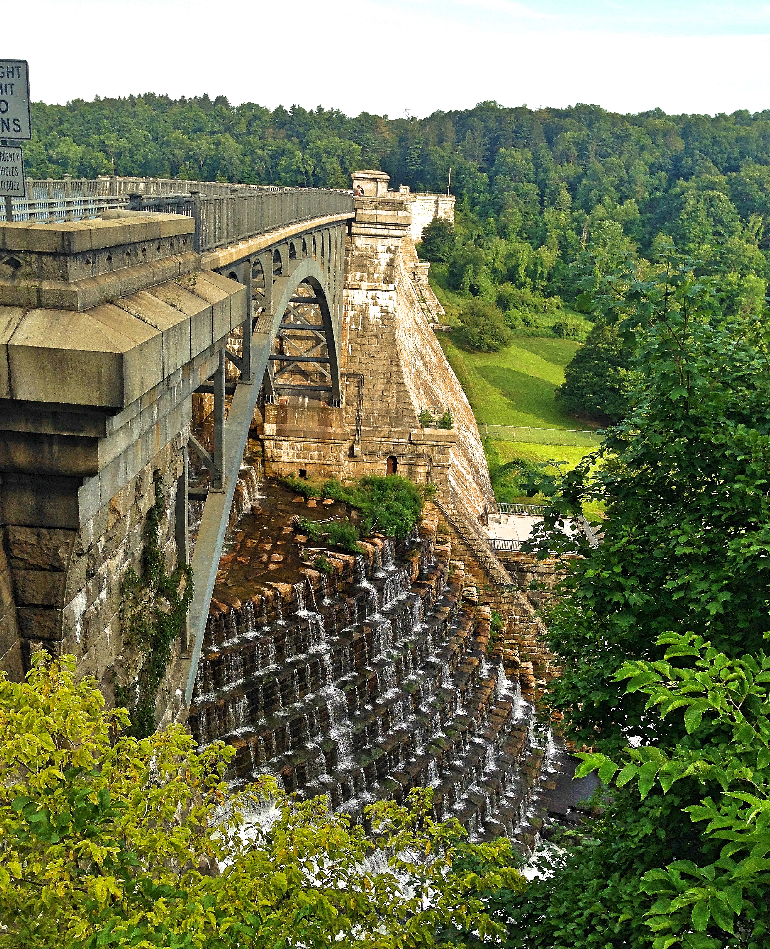
But I’m no daredevil, so I contented myself with patrolling its perimeter. Yet through the gaping windows I could glimpse the cavernous interior space, which many have compared to a cathedral nave. Indeed, compared with a gothic cathedral, the power plant is an exceedingly light, airy structure, with thin walls and plentiful windows. The towering brick façade, combined with the thin steel girders of the building’s innards, make it seem as if an elephant body is being suspended from chicken bones.
The plant consists of two buildings, the main plant and a substation next door. The substation is where the rotary converters transformed the current from alternating to direct, so the trains could use it; from there the current was sent to the rail tracks. An attractive metal footbridge connects the two buildings. Outside, a metal tower still stands, rusted and overgrown, which I believe used to hold the wires. On the southern side of the station there’s a little park. From here you can see how the station juts out into the Hudson. This must have been to enable the use of the Hudson’s water in the boilers; and, indeed, the boiler room still floods during high tide, I believe.
The plant and substation, with skybridge
I can see why Lela Goren saw potential in the plant, since its location is as attractive as the building itself. Across the river you have an excellent view of the Hudson Palisades. Looking northwards, you can see the Hudson Valley all the way up to the Tappan Zee. Looking south, Manhattan comes into view, a silhouette behind the George Washington Bridge.
From this vantage point, with the city in the distance, the river ferrying boats along its glimmering waves, it is difficult to believe that this wonderful brick building was made to simply to supply electricity to trains. It was truly a different time. At its peak, the Yonkers Power Plant could generation 30,000 kilowatts, or 30 megawatts. To put this in perspective, the Indian Point Nuclear Plant in Croton, the Robert Moses Power Dam in Niagara Falls, and the Ravenswood Generating Station in Queens can all generate over 2,000 megawatts. We have come a long way. But unfortunately for us, not one of those is even one-tenth as beautiful as the Yonkers Power Station.
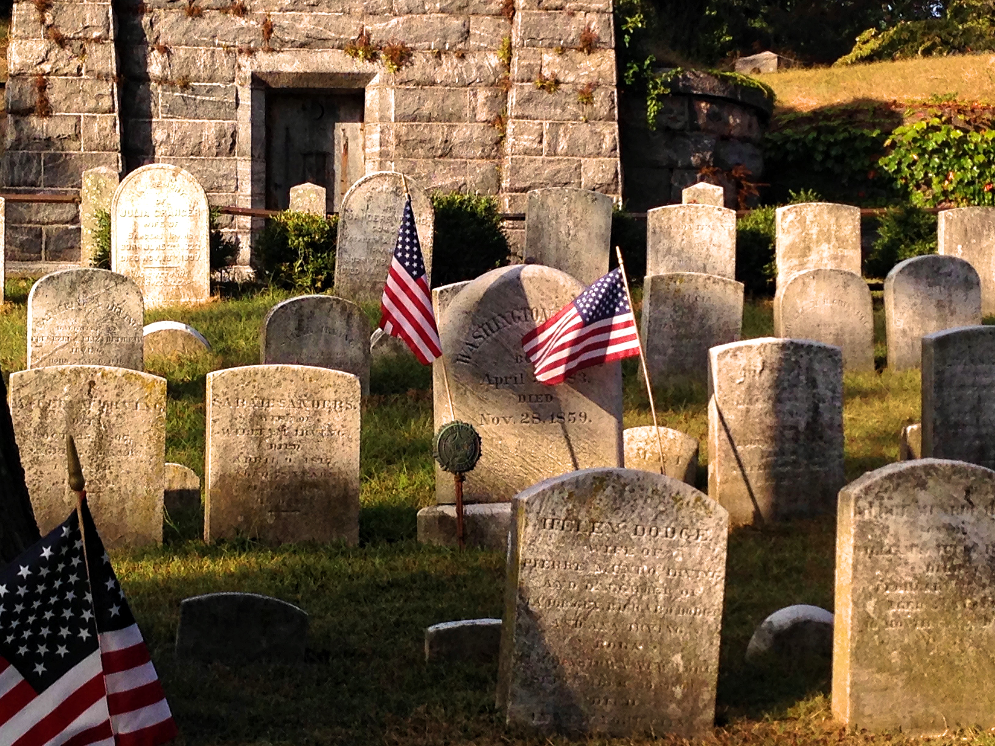
When Washington Irving published “The Legend of Sleepy Hollow” in 1820, he forever blessed—or cursed—my hometown, turning a modest cemetery in an otherwise unremarkable village in the Hudson Valley into a tourist attraction. Maybe he knew this himself, for he chose to get himself buried in that cemetery, which has since grown to a sprawling size and has gained other prestigious bodies.
One of my cousins told me and my brother, when we were both young and impressionable, that you should hold your breath when driving past a cemetery so that you don’t breathe in the evil spirits. Neither of us were superstitious enough to believe that, but it made for a fun game in otherwise boring car rides. Yet holding my breath for the entirety of the Sleepy Hollow Cemetery, as we drove down Route 9, was always a painful challenge. The cemetery is vast—or, at least, it felt vast as I turned red, and then purple, and then blue.
The free map of the cemetery
Every year around Halloween, when the fall foliage is at its most vibrant—“It was one of the most beautiful things I’ve ever seen,” said a friend from Spain who saw the New York foliage for the first time—this normally sleepy town is overrun with tourists from the city, all of them to see this famous cemetery. The cemetery is a ten-minute walk from the Philipse Manor station on the Hudson Line, making it an easy trip for urbanites. There are tours in the morning and evening, and on the weekends there are souvenir shops set up at the entrance. In the fall, closer to Halloween, you can buy freshly grilled sausages and drink mulled wine as you inspect the burials. They lock the gates at 4:30 pm daily.
The Old Dutch Church
The Sleepy Hollow Cemetery is sandwiched between Route 9, where cars continually buzz by, and the Croton Aqueduct, a trail that runs through the Rockefeller State Park preserve. The cemetery was built around, but is not affiliated with, the historic Old Dutch Church. This is a lovely stone and wooden structure, built in the 1700s near a pre-existent graveyard. The burial grounds of this church, going back to the Dutch ownership of New York, must be one of the oldest in the country. There are still tombstones written in Dutch on the property; and over the years, trees have grown up and nearly engulfed graves within their trunks. The Reformed Church of the Tarrytowns still holds services in the church every Sunday, where the congregation sits on its lovely wooden pews.
Dutch tombstone
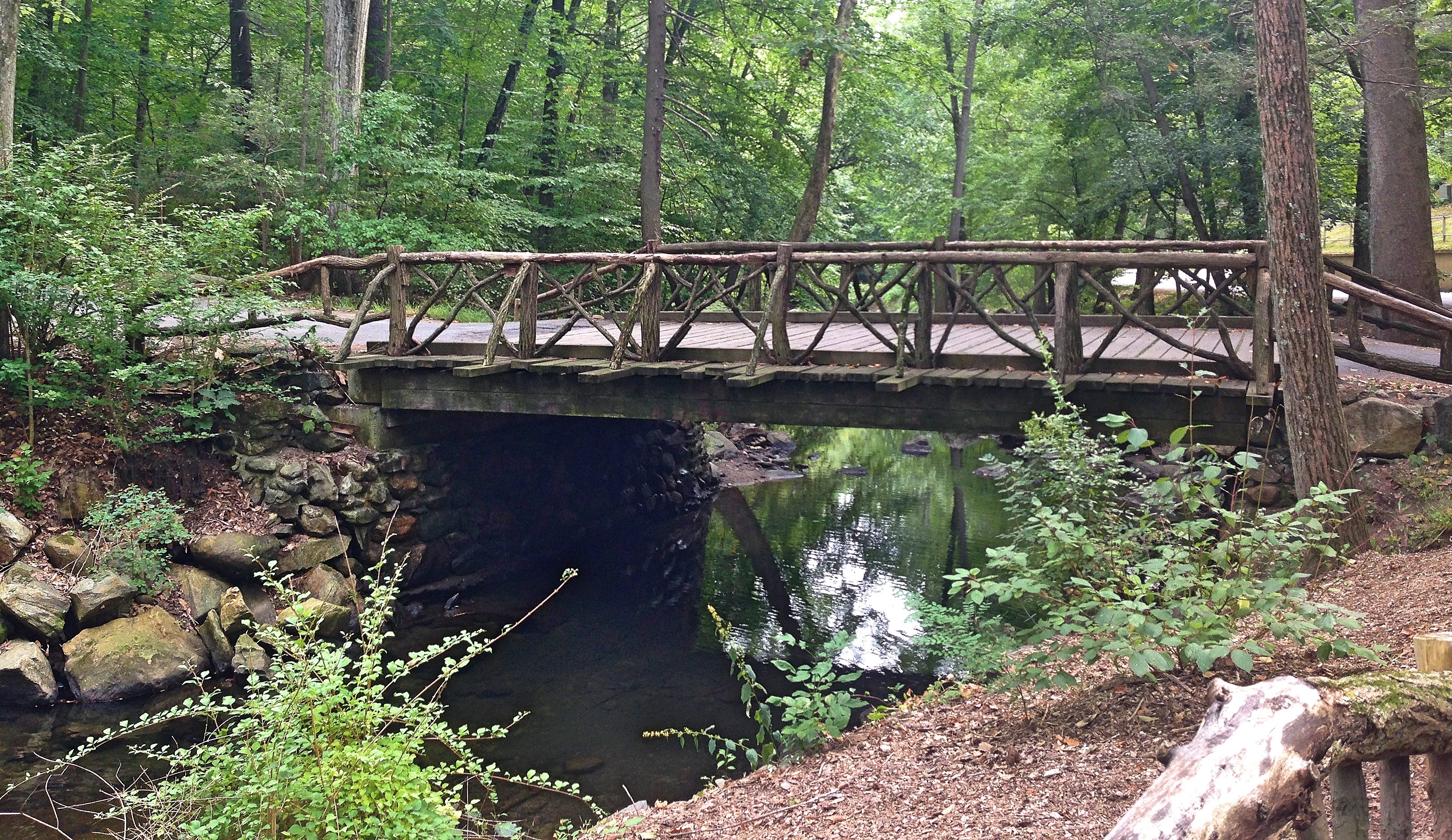
The Sleepy Hollow Cemetery itself was established much later than the church, in 1849, and is non-denominational. The website says that Washington Irving had a hand in its creation, or at least its conception. The size of the cemetery is about 90 acres. Forty-five thousand people are buried there, about twice as many as the current populations of Tarrytown and Sleepy Hollow combined. As an old brochure put it, the cemetery is a veritable city of the dead. And it is still growing. Across a wooden bridge that spans the babbling Pocantico River are the recent burials, where funerals and mourners are most often seen, and where construction equipment still busily digs new graves.
This wooden bridge, pretty and quaint with tree-trunk guardrails, is often mistaken for the bridge from Irving’s legend; but it did not exist in his day. The real location of that bridge is near the Old Dutch Church, where a sign marks its former location. Nowadays the Pocantico River is spanned by a monstrous concrete bridge in that place, which allows the busy Route 9 to cross over the water unimpeded.
When I was in high school, a friend of mine told me that his father, who worked for the cemetery, found the body of a young man who hung himself from the wooden bridge. Indeed, for many years, in the water underneath that bridge a stone plaque was clearly visible—although unreadable—which seemed to confirm the story. But now the plaque is gone—did it get washed away?—and I can’t find any information about the suicide online, which makes me wonder if the story was true.
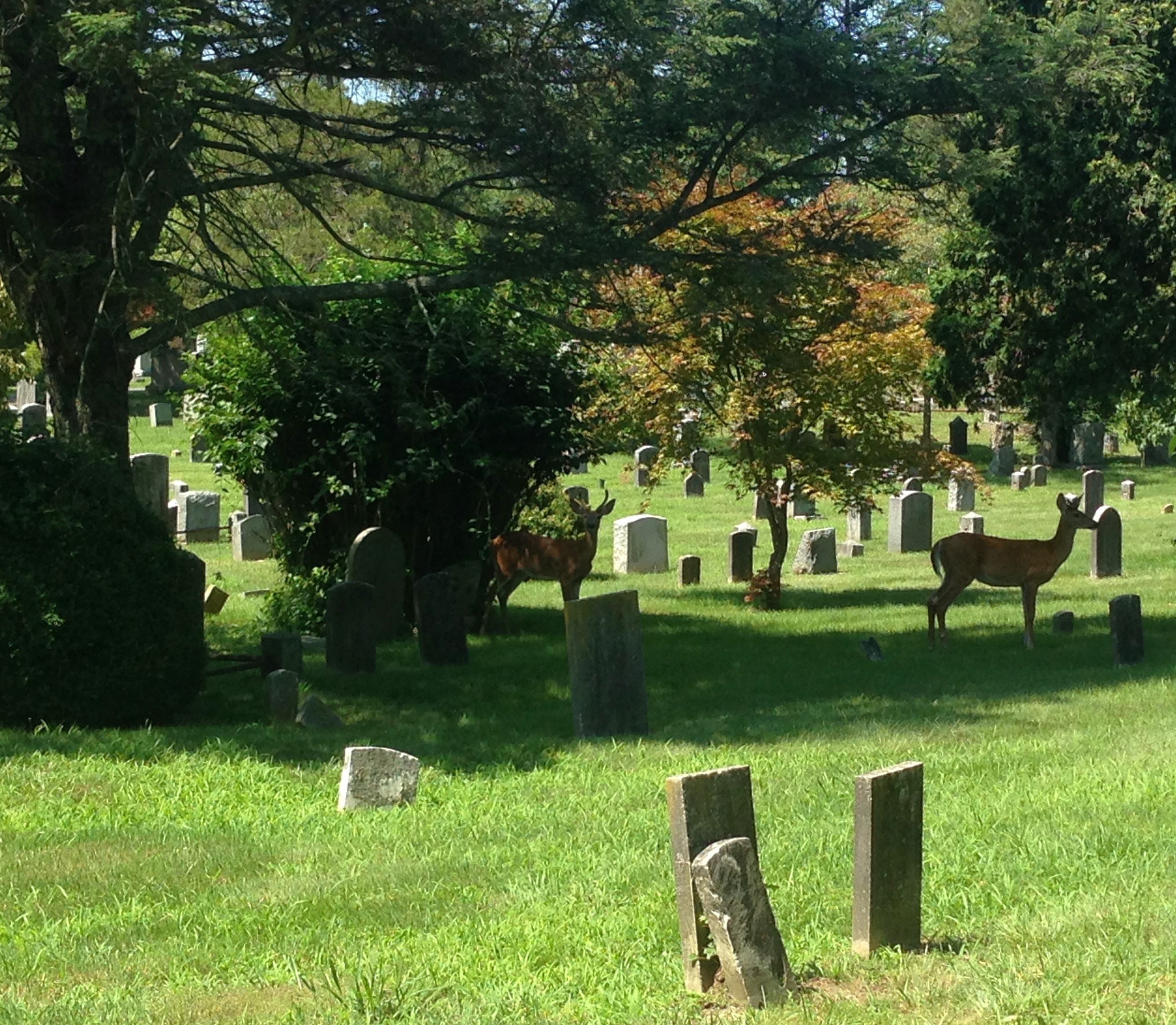
The Sleepy Hollow Cemetery is not a somber place. It is as beautiful and inviting as the finest park. I was surprised to learn that, in Spain, cemeteries have no greenery within; they are stone courtyards where bodies are interred in granite shelves and tombs. Our cemetery is almost as heavily wooded as the forest nearby, full of cedars, sycamores, and oaks, European beeches with scarlet leaves, and tiny Japanese maples whose seeds have blown into the park next door and begun to grow in the wild. There are so many bushes and ferns that the cemetery has become very popular with the local deer, who slip in through a hole in the chain-link fence. Once, in the dead of winter, I even surprised a couple of coyotes stalking around the graves, who promptly retreated to the forest.
Deer among the graves
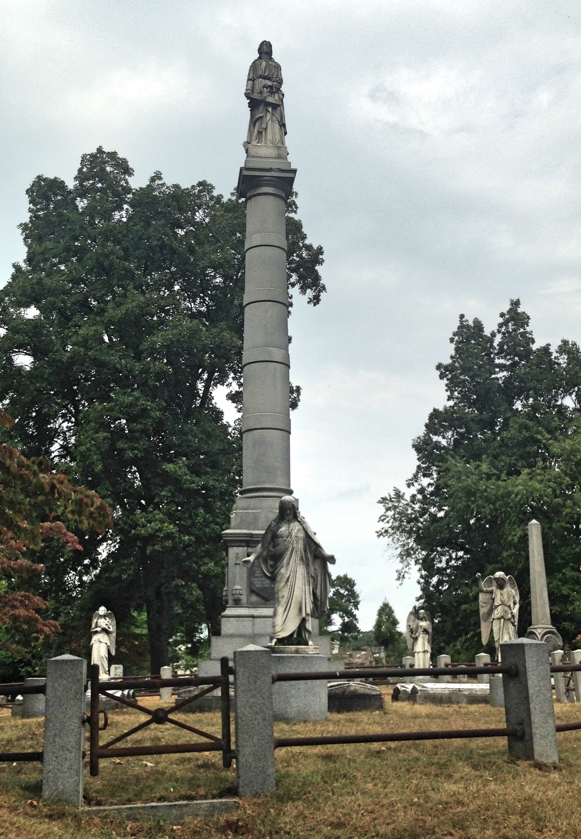
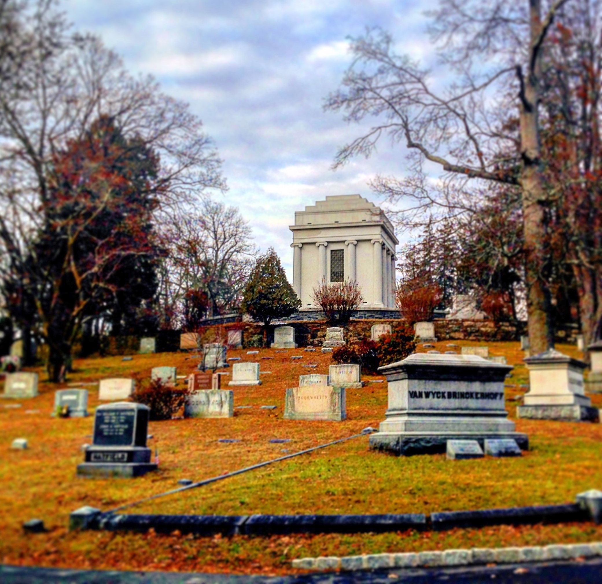
The graves and mausoleums of the Sleepy Hollow Cemetery only add to its beauty. It is as much a statue garden as a graveyard. The monument to John Hudson Hall (1818 – 1891)—about whom I can’t find a thing—was, according to this site, crafted by the famous Beaux-Arts sculptor Augustus Saint-Gaudens; and indeed it does have a striking resemblance to one of his works, Amor Caritas. I am inclined to believe that the famous sculptor was involved, considering the extreme fineness and delicacy of the angel’s robe.
One of my favorite works in the cemetery
The monument to Owen Jones (died 1884), a successful dry-goods dealer in the 19th century, features a life-sized and lifelike statue of the late merchant. Somewhat nearby is a monument to Edwin Lister (1829 – 1889), who owned a fertilizer company. Lister’s monument has a stately bust of the deceased entrepreneur, and an excellent statue of a mournful woman eternally leaning on the grave.
Owen Jones
These monuments reminds me of the Pyramid of Cestius in Rome. That pyramid is the pharonic mausoleum of a rich Roman aristocrat, which coincidentally stands near the simple graves of John Keats and Percy Bysshe Shelley—just as Jones’s and Lister’s graves stand near the simple graves of more famous men. It seems there are two ways of making one’s tomb a visiting place: accomplish something great, or invest in an elaborate monument.
The only statue to be marked on the official map (available for free at the entrance) is the so-called “Bronze Lady.” It is a twice-life-size statue of a seated woman. Her eyes are sad and downcast as she looks mournfully at the mausoleum in front of her. This is the tomb of Samuel Thomas (1840 – 1903), a relatively obscure Civil War General. The sculpture is a work of Andrew O’Connor, Jr., a sculptor of considerable reputation in his day. According to the inscription at its base, it was smelted in Paris by a famous company, the Rudier Foundry, which also made works for Auguste Rodin.
The Bronze Lady
This statue was the subject of a New York Times article called “The Other Legend of Sleepy Hollow,” and deservedly so. For several generations now, local kids have been telling ghost stories about the metal woman, reporting that the statue cries and weeps at night. Even when I was in high school, a whole century after the statue was installed, kids told stories about it. The story I was told was that, if you snuck into the graveyard at midnight, spit in her eye, spun around three times, and then looked into the little hole in the mausoleum door, you would be blinded for life. I never tried the experiment, although I have looked through the hole in daylight and wasn’t able to make out anything in the pitch darkness of the tomb. The legends are still going strong, if I can judge by the coins that are frequently deposited on her laps.
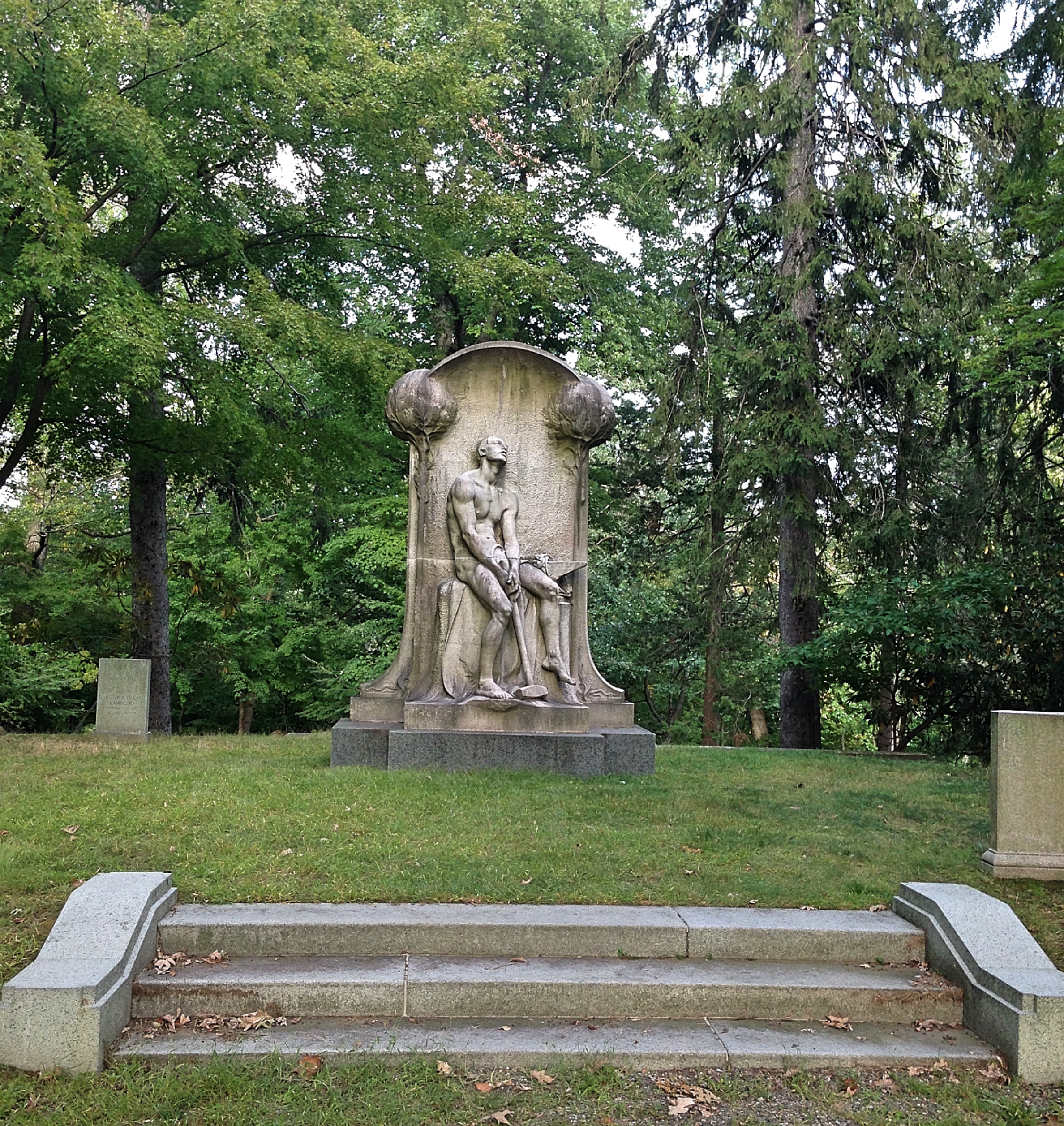
At least one more general is buried in the cemetery: Daniel Delavan (1757 – 1835). His military service goes back even further, to the American War of Independence. His actions in that war may not have been remarkable—since I can’t find anything about him—but his grave certainly is. A near life-size statue stands atop a large pillar, tall enough to be seen from my neighbor’s backyard. This pillar is surrounded by still more figures, including a moving sculpture of an angel cradling a crucifix. You can tell how old these statues are at a glance, since they’re so weather-beaten and eroded from the rains and years.
Delevan’s Monument
Accompanying its two generals, the Sleepy Hollow Cemetery has a Revolutionary and a Civil War Memorial. The former is rather simple—it was erected long after the war concluded—and consists of a small stone obelisk with the names of the soldiers inscribed. The Civil War Memorial is more impressive, with a bronze statue (now carbonated and green) of a Northern soldier, striding with his musket and bayonet over a platform that bears the names of the fallen buried there. Cemeteries and wars march side by side.
A review of the surnames of the burials here gives a taste of the ethnic makeup of the town in days gone by: Foster, Grave, Heartt, Knower, Bull, Clark, Coffin, Underhill, Newman, Newton, Small, Risk, Hackett, Hyatt. Apparently English was the dominant group—something that is certainly not true nowadays. Most graves have scant information about the people they mark. A name, a birth year, and a death year are the only facts that endure in the stone. There are some exceptions to this. One is the grave of Frederick Trevor Hill (1866 – 1933), which is an attractive plaque installed into a rocky outcrop, that informs us that he served on the American Expeditionary Force during World War I.
The Sleepy Hollow Cemetery is a sea of names, read and soon forgotten. But several famous names stick out. Washington Irving is, of course, the most famous denizen of the cemetery. His tombstone is simplicity itself, a rectangular slab with a rounded top. If flags were not flanking his grave, most visitors would probably walk right by it. A family man in life and in death—he supported his brother and his nieces when they fell on hard times—Irving is buried in a family plot. As the first internationally famous American author, his funeral was a national event. It was the subject of a Harper’s Magazine cover. So many people crowded into the Christ Episcopal Church for the event that they feared the floorboards would break.
After Washington Irving, the most notable person buried in the Sleepy Hollow Cemetery is Andrew Carnegie (1835 – 1919). Carnegie was apparently confident of immortality, since he did not create an ornate tomb for himself. His grave is a cross, about six feet high, isolated in a little grove. The cross is decorated in patterns that remind me of the Book of Kells. In the little footpath to the grave, there’s a plaque with a small portrait of Carnegie, as well as a list of the institutions he founded.
Carnegie was certainly an inspiring philanthropist, eventually donating 90% of his wealth to various charities. And he had the means to do it. Carnegie was one of the richest Americans who ever lived—and thus one of the richest people in history. A hugely admirable man, Carnegie’s reputation was slightly tarnished by his support of Henry Clay Frick (of the beautiful gallery in New York City) in Frick’s attempt to break the power of the unions in Homestead, Pennsylvania—a conflict which culminated in the death of seven strikers and three strike-breakers.
Andrew Carnegie and his wife
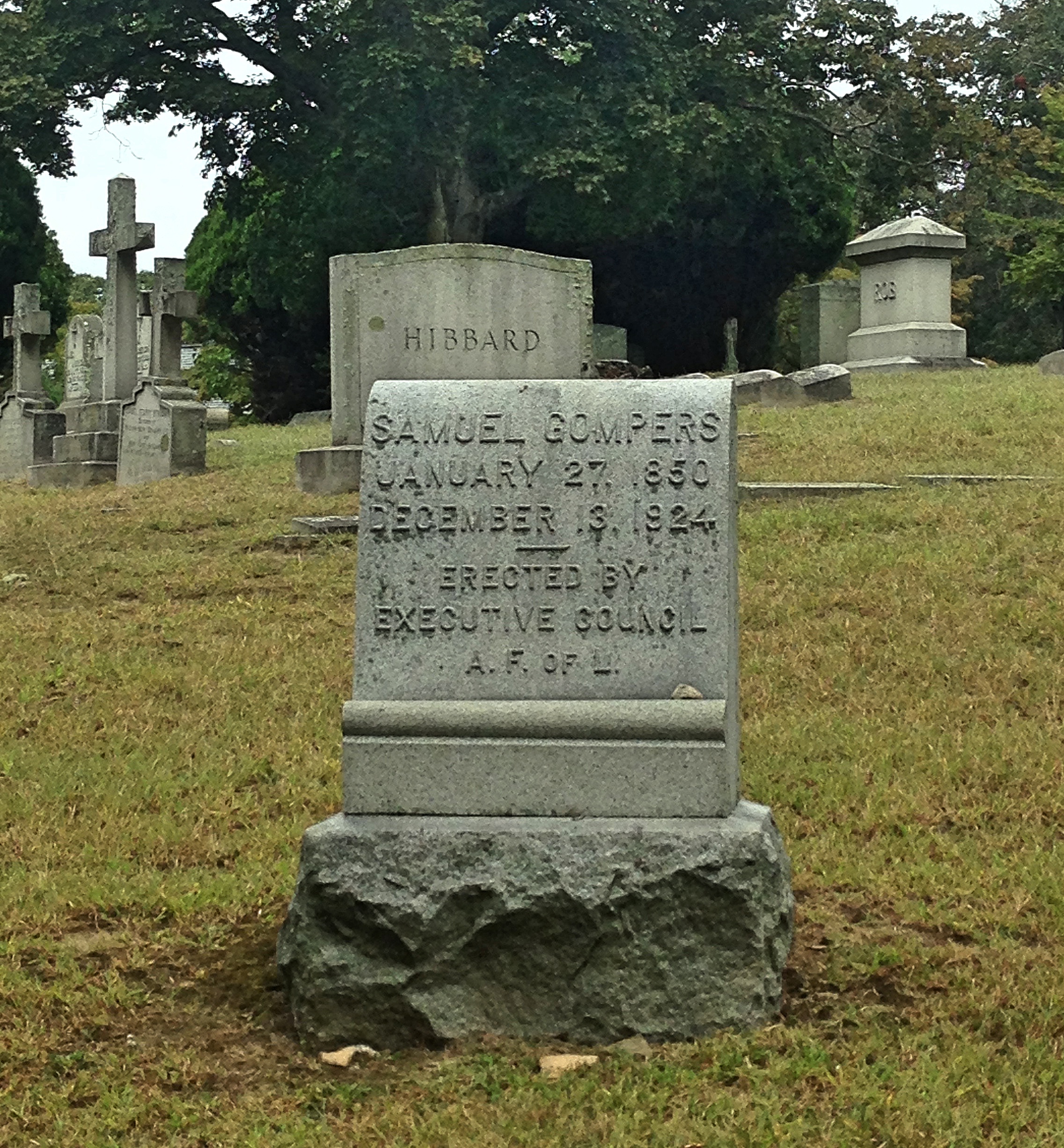
It is somewhat ironic, then, that the famous union organizer, Samuel Gompers (1850 – 1924), is buried about one hundred feet away. His grave embodies the principles of his life. Even more simple than Carnegie’s, it is a plain gray tombstone. He is not buried in a family plot; the tombstone is set amidst other burials. And it was not paid for by himself or his heirs, but by the union he helped to establish: the American Federation of Labor (AFL). Gompers was a labor organizer, who helped to join the competing guilds and small craft unions into a powerful organization, and his grave is a fitting tribute to his commitment to his fellows.
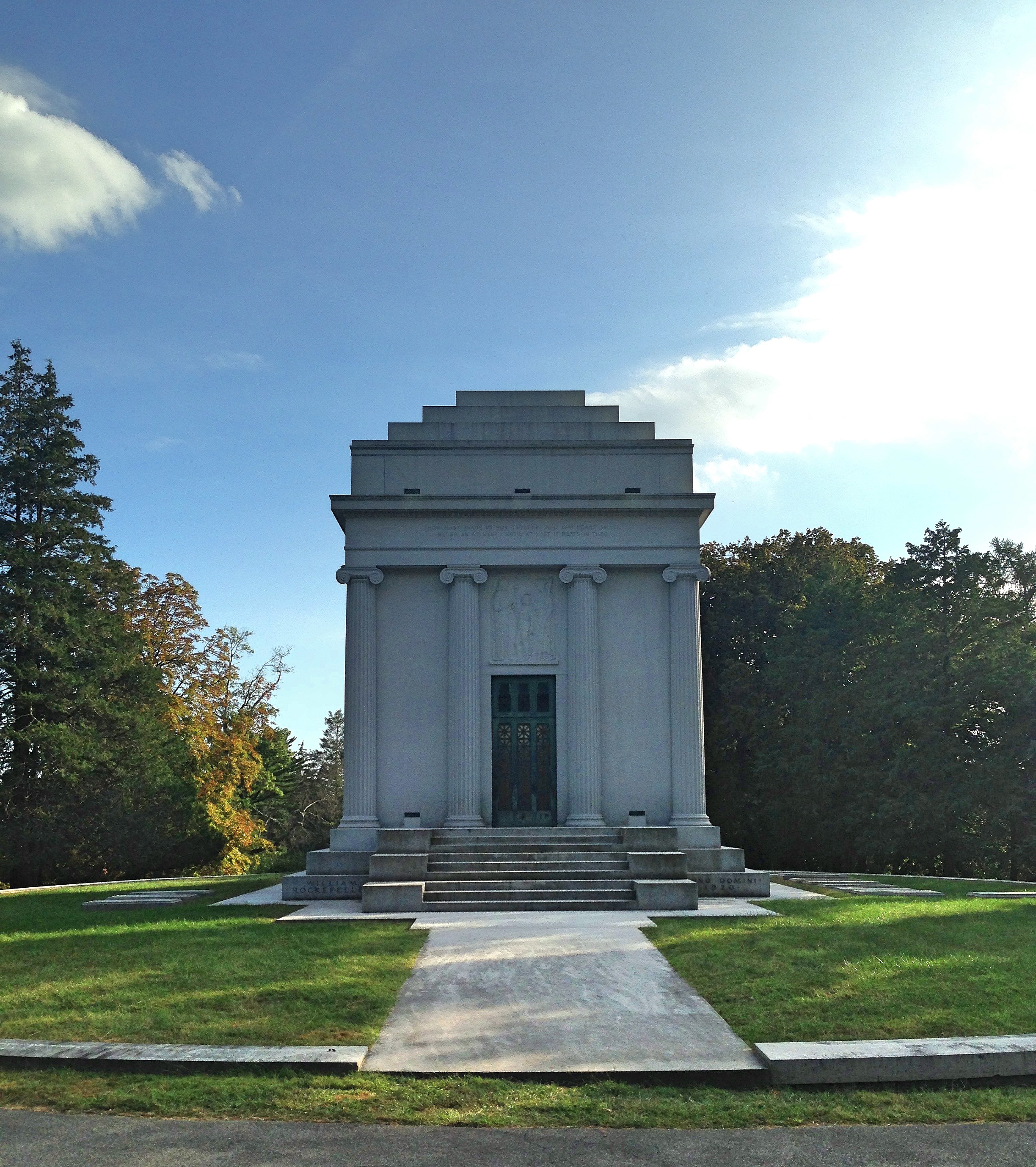
Up the hill from Gompers and Carnegie is a decidedly immodest tomb: that of William Rockefeller (1841 – 1922). William was the younger brother of the richer and more famous John D. Rockefeller. Notwithstanding his role as second fiddle, he was still fabulously wealthy, since he co-founded Standard Oil with John. William’s tomb is a massive white mausoleum, at least twice as large as the next biggest in the cemetery. The urge that actuated pharaohs to build the pyramids—the urge to monumental immortality—seems to re-emerge whenever wealth is concentrated into the hands of few, powerful men. William Rockefeller’s former residence overlooking the Hudson, Rockwood Hall, is now a State Park. The massive mansion has been torn down, but the stone walls and groundwork remain, and the view is worth the millions he must have paid for it.
William Rockefeller’s mausoleum
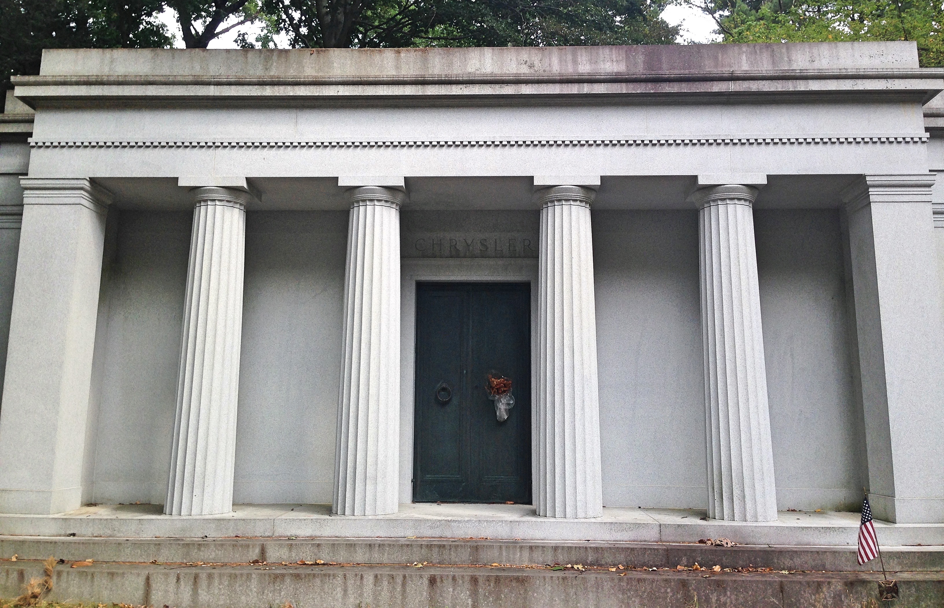
Also among the opulent captains of industry buried in the Sleepy Hollow Cemetery is Walter Chrysler (1875 – 1940). His mausoleum is a kind of neo-Roman structure with Doric columns in front. The mausoleum is located at the very end of the cemetery, its entrance turned away from the road. I must admit that this tomb always strikes me as ugly. Although it emulates a noble Roman temple, it is clearly machine-made, with inhumanly sharp angles; and the gray concrete used in the building is drab and unattractive, especially when compared with the marble originals. My father, a longtime resident of the town, admitted the other day that he has never visited the cemetery. Considering that he is a big fan of Chrysler cars, perhaps he ought to come and give homage.
Chrysler’s mausoleum
Near the gap in the chain-link fence, used by deer, coyotes, and the occasional human to pass from the cemetery to the Old Croton Aqueduct, is buried Elizabeth Arden (1878 – 1966), the famous cosmetic entrepreneur and founder of the eponymous makeup company. Arden’s grave is astonishingly modest—so much so that it is very easy not to notice it. She is buried under a tombstone with the name “Graham,” which is her real name (“Elizabeth Arden” is a pseudonym). Looking down at the little plaque, it is hard to believe that, at one time, she was one of the richest women in the world.
The grave of Elizabeth Arden
A short ways away is the last grave identified on the cemetery map, that of the Helmsleys. Harry Helmsley (1909 – 1997) was yet another fabulously wealthy man, a prominent real-estate owner in New York City whose company once owned the Empire State Building. His wealth notwithstanding, he is nowadays primarily remembered for his second wife, Leona Helmsley (1920 – 2007), the famous “Queen of Mean.” Leona was a sort of proto Donald Trump—a quick-mouthed, tyrannical, arrogant, proudly rich New York real-estate baroness, who is remembered for saying “We don’t pay taxes; only the little people pay taxes.” This quote was brought to the public’s attention during a trial for tax evasion, which resulted in her conviction and imprisonment for 19 months (the rich always get light sentences, mysteriously).
The Helmsleys’ mausoleum is very similar to Chrysler’s—a Roman inspiration—except that it is slightly bigger. I find this tomb almost equally unattractive; but if you walk up to the door and peer through, you can see a lovely stained-glass window on the other side of the structure, with an image of the Manhattan skyline illuminated in the darkness of the tomb.
As you can see from these examples, the tombs we build for ourselves can say a lot about our values. Our graves and mausoleums represent our stance on posterity. Carnegie wanted to be remembered for his charity; Rockefeller, Chrysler, and Helmsley for their power and wealth. Gompers apparently paid little heed to his grave, perhaps feeling that his work was more important than his immortal reputation. For many of us, I suspect, our anxieties about our posthumous reputation stems from anxieties about the ultimate value of our work. Compare, for example, the tombs of Owen Jones and Washington Irving. The dry-goods dealer invests enough money to preserve his likeness for future generations, while the lionized writer can rest easy under a plain headstone.
To the eyes of a cold logician, graveyards are nonsensical places. Why invest precious space and hard-earned money on a stone over a dead body? Why place bodies in expensive coffins that delay decomposition? Surely, it would be more sensible to bury our dead in unmarked mass graves, just like they do on Hart Island, and let them return their nutrients to the soil. Why build a monument or preserve a dead man’s name? The dead can make no use of their reputations; they are deaf to the tears of their relatives, and are well beyond caring whether they are remembered or not.
But I suspect that few among us could be so “sensible.” For death is not just a problem of logistics, expense, and disposal: it is an existential problem. Every culture that has ever thrived has had to confront the problem of death in some way. How can we reconcile human finitude with human striving? Why invest in the future if, inevitably, we won’t be a part of it? Death is traumatic, not just to friends and family but to communities. There must be communal rituals for death, acceptable stages of grief and routines of mourning, if a culture is to persist. These rituals allow the community to rally around the afflicted and to help pull them up, and allow the grief-stricken to put their pain in a wider context. Seen in this light, cemeteries are eminently sensible places.
Both Irving’s “Legend of Sleepy Hollow” and the legends that grew up around the Bronze Lady illustrate something the anthropologist Victor Turner said about rituals. Rituals create what he called “liminal” spaces, spaces of transition and transgression, where boys can be girls and where social norms can be flouted, and where the living and the dead can mingle. These psychological “spaces” are essential for great transitions: from single to married, from boy to man, from living to dead. Cemeteries are an example of such liminal spaces, a meeting ground for this world and the next, which is why we call them “haunted.” Haunted places allow mourners to make “contact” with the deceased and then to retreat to their normal world. Cemeteries thus play a psychological and ritualistic role essential to the community.
Yet there is an existential danger in death rituals, too. When there is a routine for death, it makes mortality easier to ignore and to push into the background. In a way, rituals remove some of the terror of death by depersonalizing it: every mourner and every funeral follows the same procedure, and every corpse is buried in the same ground. But death is always personal, and can never be routine. For every person is radically unique, and death will only visit once. And as Heidegger reminded us, when death is ritualized, we risk forgetting that our lives are singular opportunities, limited and unrepeatable, and thus risk living inauthentically. In our quiet moments, most of us feel immortal; and with time stretched out indefinitely before us, there is little pressure to act on our deepest desires.
My own walks through the cemetery illustrates this double dilemma. Most of the time it is easy to forget that the names on the tombstones were, once, actual people, living and breathing, with their own ideas and perspectives and quirks, just as individual as I am. As a result, it is also easy to forget that, one day, I will be nothing more than a name on a tombstone—and maybe not even that. There is, to be sure, something positive in this forgetting. If we went around all day dreading our death, we would be miserable creatures; and if we were constantly obsessed with the potential death of our loved ones, we could hardly form any kind of relationship.
But we do need to be periodically reminded that life is limited, or we take things for granted. Real appreciation of life requires this delicate balance between awareness of our mortality and an absence of crippling dread. An occasional memento mori will suffice, I think, to prevent complacency.
Cemeteries accomplish both functions for us: they give us a place for our rituals, and they serve as perennial monuments of mortality. This was illustrated for me just the other day, as I strolled among the graves. I was drifting along when I noticed a tombstone with toy cars resting on its base. These were the same Hot Wheels that I used to play with as a kid. On the tombstone was a name, and below it the inscription “Beloved Uncle.”
Here was a private tragedy on public display, an uncle mourned by his nieces and nephews, children who lovingly placed these toys on his resting place. My insides twisted into a knot as I looked down on the grave. I felt pity, but also a twinge of dread—the flashing certainty that, one day, I would be a beloved somebody—or even an un-beloved somebody—and that this day might, for all I know, be soon.
Processing…
Success! You're on the list.
Whoops! There was an error and we couldn't process your subscription. Please reload the page and try again.
The Old Croton Aqueduct trail runs behind my house, and I’ve been walking along its tree-shaded way for well over a decade now. As a kid, I thought “aqueduct” was just a name, until my mom told me that, buried underneath the pebbly ground, there is a tunnel that used to carry water to New York City from Croton, a couple dozen miles north. Even so, it never occurred to me to learn about the aqueduct. This a striking but common phenomenon: we travel to foreign cities and go on tours, but neglect the history in front of our eyes. It wasn’t until I began traveling abroad that I started to realize the scale and significance of the old aqueduct—along with the Brooklyn Bridge and the Eerie Canal, it is one of the major engineering feats of nineteenth-century New York—and so I set myself to investigate it.
The first step was to walk the whole thing. This is not an easy stroll. The original aqueduct ran about 40 miles from the Croton Reservoir down to Manhattan. The water first reached the Receiving Reservoir, which is now the Great Lawn in Central Park, and then traveled further along to the Distributing Reservoir in Midtown Manhattan on 42nd Street. On this spot now stands the iconic main branch of the New York Public Library, and you can still find remains of the old reservoir’s foundation in the library basement. An imposing structure inspired by Egyptian architecture, this distributing reservoir used to be something of an attraction. People would come to stand atop its walls, for what was then one of the best views of Manhattan.
After the aqueduct was phased out of service in the 1960s, a large chunk of the land—26.2 miles of trail, to be exact—was donated to New York State, to form a historic linear park that stretches from Croton, through Ossining, Scarborough, Tarrytown, Irvington, Dobbs Ferry, all the way down to the Bronx. I didn’t manage to walk the whole way, but I walked most of this distance, first going south to Yonkers and then north to Croton.
For most of the way, the Old Croton Aqueduct is a dirt or grass path, about ten feet wide or narrower, with a well-worn channel in the middle. It goes through some historic areas, taking the walker alongside the Sleepy Hollow Cemetery, through the park of Lyndhurst (former residence of Jay Gould, railroad baron), and near Sunnyside (former residence of Washington Irving), and into the wonderful Rockwood Park (former residence of William Rockefeller). The trail is not always so scenic; sometimes you are basically walking through people’s backyards, and there are a few intervals where you have to exit the trail and walk through a neighborhood to get to the next stretch.
Trail and ventillator
The walker will notice a few structures along the way. The most common are the ventilators, which are hollow stone cylinders with a shaft that allowed fresh air to reach the water below. These were installed to prevent pressure from building up inside the tunnel. Less frequent are the weirs, square stone buildings with metal sluice gates inside that could be dropped like a guillotine to divert the water in case repairs were needed. (And since the growing population of New York put heavy strain on the aqueduct, they frequently were.) These are situated above rivers, into which the water could be redirected. There is one above the Pocantico River in Sleepy Hollow, another in Ossining over the Sing Sing Kill, and another in the Bronx over the Harlem River.
Sleepy Hollow Weir
In Dobbs Ferry stands one of the old Keeper’s Houses, where the aqueduct’s superintendents used to stay. There used to be six of these along the aqueduct, but the one in Dobbs Ferry is the only one that still stands. It is an inconspicuous white house now, but not long ago it lay completely in ruins; the restoration was just completed in 2016, by the combined efforts of the Friends of the Old Croton Aqueduct, a non-profit volunteer organization dedicated to the aqueduct, and the State of New York. This house is open on weekends and is well worth a visit. It contains many exhibits about the aqueduct, with historical photos, engineering drawings, and maps, and also has several short documentaries you can watch.
Sluice gate
Up north in Ossining there is a stone bridge that carries the aqueduct over the Sing Sing Kill. (“Kill” comes from a Dutch word, meaning “river,” and is used in several place-names in New York.) A few times a year, The Friends of the Old Croton Aqueduct give free guided tours that actually bring you inside this bridge. I recently went on one, and I recommend the experience. A group of about two dozen visitors descended through the weir into the aqueduct. The old sluice gate is a rusty mass of metal now. But the aqueduct tunnel itself, made of brick and waterproof concrete, has held up remarkably well. The only marks of wear are some cracks in the walls from running the aqueduct at full capacity. It made me giddy to think that I could walk through that dark and dank tunnel all the way to New York City.
Inside the Aqueduct
Below this bridge, there is an elevated walkway (a “greenway”) where you can stroll alongside the Sing Sing Kill. This was just opened last year, in 2016, and is astonishingly lovely. From this you can see the spillway, which brought the water from the aqueduct into the river during repairs. As the guide noted, the water would spray out with such force that it scoured the bank on the other side of the river.
Sing Sing Kill spillway
From the information available in the Keeper’s House and the Ossining Visitor Center—from permanent exhibitions and documentaries on display—I pieced together the history of this great work. The original aqueduct and dam were commissioned in the 1830s after it became apparent that New York badly needed more water. Outbreaks of yellow fever and cholera killed thousands; and the Great Fire of 1835 destroyed hundreds of buildings, largely because the fire department lacked the water to put it out. Manhattan is an island of marshy ground surrounded by brackish water, and before the Croton Aqueduct was built the only water supplies were local wells which could be easily polluted.
Sing Sing Kill greenway
The man primarily responsible for planning and engineering the original aqueduct was John B. Jervis, who must be one of the great engineers of 19th century America. He had political as well as engineering challenges to surmount. The land needed for the tunnel cut through hundreds of properties, mostly farms, each of which required an individual settlement. Meanwhile, the two political parties of the time, the Whigs and the Democrats, were squabbling over funding. Upon completion of the project, Jervis rode in a rowboat through the tunnel all the way from Croton to New York. I don’t know how long it took him, but it takes the water 22 hours to make the journey. This slow speed was intentional, by the way, since it minimized wear on the tunnel.
Original High Bridge arches
The largest structure of the original aqueduct stands on the southern end. This is the High Bridge. Opened in 1848, this is the oldest bridge still standing in New York City. It originally resembled a Roman aqueduct, with tall stone arches carrying the water high overhead, just like the famous aqueduct in Segovia. Indeed, one remarkable thing about the Croton Aqueduct is that it uses the same principle the Romans used all those centuries ago—namely, gravity—transporting the water on its 40 mile trip with a slight incline, 13 inches per mile. The bridge had to be built so high (140 feet) to maintain this slope. The water tower Jervis designed still stands on the Manhattan side of the High Bridge, looking like the turret of some bygone castle. (This tower was needed to pump water to some areas in the Bronx, which lay above the Aqueduct’s slope.)
Water tower
In the 1920s people began to complain that the bridge’s arches were an obstacle to ships traveling through the river, so the middle stone pillars were demolished and replaced with a long steel arch. The bridge was officially closed to the public in 1970, apparently because of vandalism, and wasn’t opened until 2015—an astonishingly long time, if you ask me. (There are some excellent panels on the High Bridge, with illustrations of its history. I have attached the images at the end.)
High Bridge
As you can see from the High Bridge, the scale of the Old Croton Aqueduct is undeniably impressive: stretching about four times longer than the Aqua Appia in Rome (although, to be fair, I think the Romans built several aqueducts longer than the Croton Aqueduct), and requiring whole landscapes to be reshaped. The aqueduct was constructed by 4,000 laborers, mostly Irish, who made a dollar or less for ten-hour days. Having thousands of single men, with plenty of drink available (enterprising farmers began converting their barns into bars), predictably caused some ruckus. But it was a good job for the recent immigrants.
The opening of the aqueduct was something of a sensation. At the time, the Croton Aqueduct was one of the biggest engineering projects in the United States, only surpassed by the Eerie Canal. And the effect of the aqueduct on city life was scarcely less important than the canal’s. With a reliable source of clean water, the city began to expand at a remarkable rate. The original aqueduct was built with a maximum capacity of 60 million gallons a day. The engineers thought this would be enough water to supply the city for hundreds of years. But it wasn’t long until the ever-growing population of New York outstripped the capacity of the aqueduct. Indeed, it was largely thanks to the increased supply of fresh water that the city was able to grow so quickly.
Thus the aqueduct, designed to be used for centuries, was supplemented in 1890 by the New Croton Aqueduct, a larger tunnel that runs parallel to the old one. The Old Aqueduct stopped delivering water to the city in the 1950s. The New Croton Aqueduct is still in use—although it, too, has since been supplanted. The Croton watershed now delivers about 10% of NYC water. The majority of the water comes from the Catskill Watershed further north, ferried to the city by the Catskill and the Delaware Aqueducts. This latter tunnel, by the way, is the longest tunnel anywhere on earth, stretching 85 miles. New York is a thirsty city. (The current daily water supply of NYC is 1.3 billion gallons.)
Not only the original aqueduct, but the original Croton Dam was also replaced in the late nineteenth century. Jervis designed the original dam with an innovative S-shaped spillway to reduce damage from floods. But good luck seeing it now. Today, Jervis’s dam is underwater, submerged under the expanded Croton Reservoir, only visible in times of severe drought.
For my part, I don’t regret this loss, since that dam was replaced by the New Croton Dam—a grand monument of the previous century. Made of cyclopean stones, standing at almost 300 feet tall, and stretching to 2,188 feet (almost the exact altitude of Madrid, coincidently) the dam is still immensely impressive. It is also beautiful, with the stair-like spillway allowing water to cascade down to the river below in an artificial waterfall. This dam was begun in 1892 and completed in 1906. Whole communities—cemeteries, churches, and farms—had to be moved to make way for the expanding reservoir. Standing on top of that dam, hearing the rushing water below you, does a better job than any statistic of conveying how much water a major city like New York needs.
As part of my research, I also read the book in the Images of America series about the construction of the New Croton Dam. The story of this construction is told with dozens of old photographs, with commentary by Christopher Tompkins. You don’t exactly get a linear narrative this way; but the images alone are worth the price. It baffles the mind to think of what these men accomplished—redirecting a river, and erecting a structure 300 feet tall with cut stones, flooding an entire valley and displacing many communities—and all this using technology that looks, to my eyes, scarcely more advanced than what the Egyptians used. That’s an exaggeration, of course: the dam workers had steam shovels to excavate and railroads to bring stone from the quarry. But I can’t imagine how difficult it would have been to move those massive stones in a time before modern cranes, using only wooden derricks and pulleys and counterweights.
It is amazing to me that so much history—an engineering feat and a chapter in the history of New York—lay buried right behind my house, and that I’ve been walking along this trail for so many years, oblivious. Don’t wait until you travel to learn about history, to explore and go on tours. Take Thoreau’s advice: “Live at home like a traveler.”
These images are taken from informational panels on the High Bridge.
Processing…
Success! You're on the list.
Whoops! There was an error and we couldn't process your subscription. Please reload the page and try again.
This is a continuation on my first post about life in Berlin, focusing on the darker side of the city’s history.
Historical Memory
Memory is not passive—either in a person or in a country. We choose what we remember; we can shape how we remember it; and our memories, in turn, shape how we act. History is messy, the truth is neither plain nor simple, and in human affairs there is no such thing as an apolitical fact. Opposing groups emphasize different episodes of history, interpret (or misinterpret) those episodes incompatibly, and sweep aside inconvenient episodes that do not fit their narratives. These narratives are not just background; they provide groups with their identity, giving them a historical trajectory and a goal to strive for. Thus it is not just for the dead, but the living, that we must attend to how history is remembered.
Nowhere is this need more apparent than in Berlin; nowhere can we see more clearly what power historical memory can wield. It is said that knowledge is power, but in history we had better say narrative is power. For the past is past, and not around to refute politicians who twist it to their advantage. The historical past is, to a large extent, a creation of the present; and it is recreated every time a book is written, a speech is delivered, or an article is published in the newspaper. The past that the Nazis created was of a mythic Germany, of a virtuous and heroic people, unduly hampered by foreign elements and racial impurities. The past that the Soviets conjured was of a dark night of bourgeois repression only recently lifted by the liberating proletariat army. As we all know, these narratives gave rise to atrocities—atrocities which, if the narratives had triumphed, we would remember as victories—and thus we are now faced with the task of remembering differently.
For this reason, a trip to Berlin is both horrifying and heartening—horrifying because of the crimes committed there, heartening because those crimes are not being ignored or swept aside. I have mentioned elsewhere that you can visit Madrid and never guess that, less than a hundred years ago, there was a horrendous civil war that ended with mass executions. The same cannot be said of Berlin. Indeed I think Berlin is a model of how historical atrocities should be framed and memorialized. The city has every reason to be proud.
Monuments of Death
The first of these somber monuments I visited was the rather cheerfully named Checkpoint Charlie. The name is really just Checkpoint C (Charlie is the NATO phonetic marker for “C”). Checkpoint Charlie is the most famous border crossing between East and West Germany.
As you may know, defection from East to West was high during the postwar years, particularly among the young and well-educated (not population most countries want to lose). To prevent this, the border between East Germany and West Germany was sealed off, and strict regulations put in place about leaving the country. But for many years the border crossings in Berlin remained much easier to get through (this was because the city was jointly controlled by the four occupying powers), making Berlin a kind of gateway to freedom for many hoping to flee the Soviet Union. All this ended in 1961 with the erection of the Berlin Wall. By that time, East Germany had lost 20% of its population.
In truth the checkpoint isn’t much to look at. It’s a small, white guardhouse with some sandbags sitting out front. There were two men in uniform carrying American flags. I was unsure whether they were actual American soldiers or enterprising men in costume accepting money to pose with tourists. In any case, the most memorable image of Checkpoint Charlie is the sign that says “YOU ARE LEAVING THE AMERICAN SECTOR” in four languages—English, French, Russian, and German. On the other side of the sign, for those entering the American Sector, we are kindly reminded to “OBEY TRAFFIC RULES.”
The official Checkpoint Charlie Museum is nearby. I didn’t go, since I heard mixed reviews. I don’t have anything more to add about this famous landmark, other than that it was strange to be standing in that otherwise entirely ordinary road, and imagine tanks rolling in, diplomats being escorted by soldiers, and the fate of the world hanging on the de-escalation of tensions surrounding this border crossing. In politics, small flames can set off very large explosions. Seen with un-political eyes, Checkpoint Charlie is a shack on a road. Seen with historical eyes, it is one of the axes of world history.
From Checkpoint Charlie it is a five-minute walk to my next monument, the Topographie des Terrors. This is a fairly new exhibit—opened only in 2010—built on the ruins of the old Gestapo headquarters, where their prisoners were tortured and killed. As befitting its name, The Topography of Terrors is an open-air museum dedicated to the history of Nazi atrocities. This history is arranged as a timeline, with plentiful pictures and information panels giving examples and details of the National Socialist regime.
Most of this information will not be new to anyone with a basic knowledge of the Holocaust or the Nazi movement—although familiarity hardly dulls the sickening horror of it all. The museum is more valuable for its ability to convey the atmosphere of the time, especially with the numerous Nazi propaganda posters on display. Nothing sums up an ideology with the stark simplicity of a propaganda poster. We see a hardworking German Aryan worker struggling to work, while weighted down by the lazy inferior races; we see bald-faced incitements to hatred against Jews; we see rallies for the workers at home to fight as hard as the soldiers in the field; and then there are the usual posters warning citizens to black out their lights during air raids and to watch out for spies.
Scattered among the posters are profiles of the fallen. One profile which struck me was of a man with epilepsy, Otto Mathewes, who was put into a sanatorium by his family, sterilized by the Nazis, and ultimately sent to a death camp to be killed. I knew that the Nazis targeted those they deemed racially impure—Jews and Roma—as well as homosexuals; but I did not know that the Nazis would put to death somebody with epilepsy—a treatable disease, or at the very least one that could be managed. For me, as for many, the most perplexing thing about the Nazi movement is how an entire population could be goaded into cooperating with their murderous policies. Most populations, it seems, can be persuaded to go to war, which involves killing outsiders. Yet the Nazis didn’t only wage war, but killed citizens of their own country. Why wasn’t there widespread resistance? Hannah Arendt’s phrase about the “banality of evil” comes to mind; but I suppose this question is not one to be answered with a phrase.
Among the propaganda posters, I found a chart showing the different paths for Nazi youths to follow to become full-fledged Nazi adults—for women, from Jungmädel (young girls) to Mütter und Hausfrauen (mothers and housewives), for military boys from the Hitler youth to the military. Looking at that chart, I feel a mixture of disgust and amusement. Such a regimented society, with caste-like roles and ranks for everyone, is repressive in the extreme. And yet, for all its nefarious intent, this organization strikes me as hopelessly juvenile. Indeed it is even campy, as if the whole country is to be organized like the Boy Scouts. Considering this chart, it is easy to see why many Germans did not consider Hitler a serious threat before he rose to power. His mind was packed full of this stuff—juvenile, campy plans designed to appeal to a boyish desire for ritual, hierarchy, and order. The line between the notions of an oaf and the ideas of an autarch is disturbingly fine—perhaps ultimately just access to power.
The exhibition also includes a model for Welthauptstadt Germania, “World Capital Germania,” the proposed city to be constructed over Berlin after Germany won the war. This plan, drawn up by Albert Speer, is discussed by Robert Hughes in his documentary The Shock of the New as an example of the architecture of power. Everything about the design is meant to provoke awe. The scale is enormous; the proposed dome of the Volkshalle would easily dwarf St. Peter’s and the Pantheon. Again, we see here the big imaginations of little minds. It is the same mixture of a juvenile yearning for order and a boyish admiration of strength that we see in the chart.
Coincidentally, the Topography of Terror is located right next to the longest extant stretch of the outer Berlin Wall. It is little more than a wreck now, so full of holes you can see right through it. That ruin completes the picture of atrocities, giving the visitor a glimpse of what came after the Nazis were defeated.
It is a short walk from the Topography of Terror to the Holocaust Memorial, more properly called the Memorial to the Murdered Jews of Europe. Designed by the American architect Peter Eisenman, it opened in 2005, and is situated near the Brandenburger Tor. The memorial is strikingly abstract. There is no information to be found, no names of victims, no sculptures or symbols, nothing that can provide the visitor context. Instead, the visitor finds a field of concrete slabs, 711 of them, ranging in height from 8 inches to over 15 feet. These slabs are arranged in rows and columns, slightly askew, and the monoliths grow as the visitor enters into the monument.
I admit that my first impression was one of disappointment. There just isn’t much to look at—just identical grey blocks, stretching out like a miniature city. Is the meaningless abstraction of contemporary art really appropriate for commemorating the Holocaust? But I revised my opinion as soon as I walked into the memorial. The blocks slowly grow until they encompass you and limit your line of sight to four narrow passageways. I felt uncomfortable, even unnerved. It is easy to get separated from friends, and difficult to find them once lost. There is no telling who you will see if you turn a corner. Muffled voices come from all directions. I am not prone to this, but I felt a kind of crushing claustrophobia in the monument, a sense of being hopelessly lost and in danger, and I hurried to get out.
As many have noted, the memorial lends itself to many interpretations. The concrete slabs are shaped like coffins, and the rows of blocks strike many as a graveyard. The gradual increase in the slabs’ height as you walk into the memorial, rising until all lines of vision are cut off, is symbolic of the gradual limiting of the Jews’ options as the Nazis stripped them of rights, property, liberty, and life. The mechanical regularity of the slabs suggests the inhuman efficiency of the Nazi killing machine. But more important than these interpretations is the feeling evoked by the monument, the uncomfortable, suffocating feeling of being trapped. It is a cold and comfortless place, although kids are often found playing hide-and-seek within. Indeed the monument invites use as a playground, and it is easy to imagine people skipping from block to block and dashing through the columns. And perhaps this, too, forms an essential part of the monument, showing us that children can turn even bleak concrete into innocent fun.
The monument does not impress everyone; it has been controversial from the beginning. Richard Brody wrote a piece in The New Yorker criticizing the memorial for being too vague and for not including the names of the victims. (As he notes, the names on display in an information center under the slabs, along with other documents about the atrocity. But this information is not well marked, and both Brody and myself missed it.) More recently there was a social media story about Shahak Shapira, who took pictures of tourists taking selfies in the memorial, and juxtaposed them with images of the holocaust—terming it the ‘yolocaust’. I admit that it doesn’t surprise me that people take selfies at the memorial. Nowadays, people will take a selfie with the murderer who just broke into their house, and spend their final moments counting likes.
For my part, I thought it was a moving and effective work of art, even though I was skeptical at first. While I can see why some criticize the lack of names or context, I think the silence of the memorial is what gives it such emotional power; it is a silence that invites us to contemplate the absence of all those men, women, and children, those who were taken and can never return.
Berlin’s other famous memorial is not within easy walking distance. The Berlin Wall Memorial (Gedenkstätte Berliner Mauer) is located to the north, next to another surviving section of the wall. It was opened to the public in 1998, within a decade of the reunification. It is much more “traditional” than the Holocaust Memorial, with explicit messages, historical recreations, and information about the victims. Nearby is the Chapel of Reconciliation, an oval-shaped church made of thin strips of wood—you can see through the walls from the inside—built over the foundations of an older church demolished to make way for the wall. A statue of a man and woman in a desperate embrace reminds us how many families were split by that barrier.
The main attraction of the memorial is a section of the wall reconstructed to look as it would have when it was dividing the city in two. This recreation is bounded by two high steel walls, preventing visitors at ground level from looking inside. The viewer needs to climb a tower across the street, right next to the memorial building, and look down from above. From there you can see that the Berlin Wall was really two walls, an exterior and an interior, both of the same drab gray appearance. It is steel-reinforced concrete, too tall to climb easily, too strong to ram with any normal car. Between the two walls is what was called the “death strip,” an empty area full of gravel raked smooth, with a small road running through the center so that army vehicles could quickly move to different sections. This strip was deadly because any potential escapees would be totally exposed there, easily visible to those in the guard tower nearby. There is no cover from searchlights or from firearms. Street lights kept it constantly illuminated. Caught there, you would be a sitting duck.
Although it was a beautiful sunny evening, and although it is surrounded by green parks and bushy trees, the wall section struck me as inhuman, dreary, and squalid. It is the picture of homicidal efficiency—a barrier designed with intelligence and foresight to accomplish immoral ends. The same question occurs to me here as occurred to me at the Topography of Terror: How could people—presumably normal, neighborly people—be persuaded to build something like this? The sheer absurdity of building a wall to keep people in rather than out, to stop an exodus of people fleeing from their own country, must have struck everyone involved. And yet the wall was built, construction crews dragged the concrete into place, soldiers manned the watchtowers, and government officials devoted time and energy to its maintenance and improvement.
Inside the memorial center are old letters, recorded interviews, and information panels about those whose lives were affected by the wall. There are stories of people fleeing, being caught in the attempt, and getting shot down by guards. One famous escape story is of Wolfgang Engels, who stole an armored personnel carrier and rammed it through the wall, getting shot in the process but making it out alive. East German Soldiers at the wall were instructed to shoot anyone attempting to cross, even women and children. Nevertheless, about 5,000 people successfully escaped; well over 100 were killed in the attempt. Some of the escapees dug tunnels, some even flew balloons—indeed, the last casualty of the wall, Winfried Freudenberg, died in 1989 when he fell from his homemade balloon. Guards on the Western side could not help anyone on the death strip, or they risked being fired on by the East German guards. This led, most famously, to the death of Peter Fechter, who was shot in the death strip and left to bleed to death, as hundreds looked on from both sides.
The last place I visited was the Berlin-Hohenschönhausen Memorial, an old Soviet and then Stasi prison. This is situated far away from the other major sites, in the east of the city. But it is well worth the trip. The only way to visit the prison is on a guided tour. My tour guide, a young woman, was excellent—extremely knowledgeable and compelling. According to her, some of the guides are actually former inmates in the prison. In any case, I can say that it was one of the best guided tours of my life. My visit was both informative and moving, and I hope you get a chance to go.
As I said, the Berlin-Hohenschönhausen is a prison formerly used by the Soviets and the Stasi. Before that, it was used by the Nazis as a communal kitchen. When the Soviets conquered Berlin, the building was used hold prisoners—accused Nazi collaborators. The building was not designed for this. The Soviets put their prisoners in the food cellars in the basement—big subterranean rooms with no windows. Conditions for prisoners were atrocious. The cells were unheated and terribly cold in the winter. The Soviets did not distribute clothing to the prisoners, so if they were unlucky enough to be thrown in without a coat, they had no recourse but to freeze. The cells had no bathroom, only a single chamber pot—without even a lid, so the place constantly reeked—that was seldom emptied. Soldiers had no showers, and no medical attention. If memory serves, the guide said they were fed once a day, and poorly. Death from starvation, cold, and sickness were common. Beatings and other forms of torture were used to extract confessions. Conditions were so inhumane that many attempted suicide; but since there was nothing in the cell, no sharp objects or chords, even this was difficult.
Conditions improved somewhat when, in 1951, the Stasi took over. Instead of using the old food cellars, they built an actual prison building. The cells were above ground, with windows, and had a toilet, a sink, and a mirror. The guards didn’t carry guns, for fear that the prisoners might steal one. In the hallway outside the cells, running along the wall, is a chord that, if tugged, sets off an alarm. Prisoners were not allowed to speak to each other, or even exchange glances, outside the cells. According to the guide, the Stasi used psychological forms of torture more often than beatings. Interrogators would try to gain the prisoner’s confidence, to use a mixture of threats and friendliness to get what they were after. Sometimes more stringent forms of torture was used, like sleep deprivation. In any case, prisoners had to sleep with their arms outside the blanket; and guards would come several times a night to shine a light inside the cell, checking that their arms were in view. The only outside recreation they were allowed was in what was called the ‘tiger cage,’ a small enclosure with high walls and a caged roof.
Incredibly, the prison was completely unknown to the public while it was in use, even though it is a large compound in the capital. This is partly why it remains standing in such pristine condition. Almost nobody knew about it; so after the fall of the Berlin Wall, angry demonstrators didn’t come pouring in the gates. Part of the tour included the unmarked van used to pick up prisoners without detection. According to the guide, after the wall fell, former prisoners sometimes bumped into their erstwhile interrogators. In one anecdote she recounted, the interrogator refused to apologize; but in another, the interrogator said he was sorry for what happened.
I have recounted the tour as best as I remember it; but this brief summary does not capture the feeling of standing in those dark cells, seeing the interrogation rooms—eerily office-like—and thinking of all the people who suffered and died here while their loved ones waited in total ignorance of their whereabouts. The whole environment was designed to be dehumanizing, to make life as uncomfortable and as fearful as possible for the inmates.
This completes my short experiences with the somber memorials of Berlin. There is not much more to be said. I left Berlin with a keen awareness of the terrors that took place within recent memory, and with a deep respect for the citizens’ commitment to remembering these terrors. These monuments are built to commemorate crimes, crimes that reveal the lowest depths of our nature. That these monuments were built—in the very heart of the country where these crimes took place—shows us the heights we can rise to.
Here goes another travel post delayed by a year. Now, however, I don’t feel quite so bad, since I learned that the famous travel writer, Patrick Leigh Fermor, wrote his account of his youthful travels over 40 years after the trip itself. So maybe I’m not such a nincompoop after all. (For part 2 of this post, about the ugly history of Berlin, click here.)
Germany in Mind
Germany: The very word looms over my whole conception of the world.
Like so many of my bewildered generation, when I was in high school I spent a lot of time watching television. The problem, then as now, was that nothing was on. In desperation my brother and I often turned to the History Channel. If we were unlucky, Modern Marvels would be on—a show about the history of automobile manufacturing, or how screws evolved from nails, or something similarly dry. (This was before the History Channel became the Conspiracy Theory Channel, and had no programs about ancient aliens.)
The good stuff were the World War II documentaries. Grainy footage of soldiers marching across barren landscapes, the whistling of bombs released from bombers, stupendous explosions and the bright streaks of tracer bullets fired from fighter planes—all these scenes of battle, so captivating to young boys, were mixed up with footage of one man: Hitler. Every documentary was sure to feature that stiff, stern, mustachioed man yelling shrilly, punctuating his pronouncements with jerky gestures.
It is an injustice to the German language that so many people are exposed to it through the oratory of that execrable man. Naturally, the language in that tyrant’s mouth is violent, aggressive, ugly, shrieking, garbled—as were his thoughts. But the abuse of one man ought not to cast aspersions on a whole language. Spoken well, German can be gentle, sweet, and tender.
I fell under its spell from my very first exposure. In the sixth grade we had a language survey, covering bits of Italian, Spanish, French, and German, to see which language we wanted to study. At the end of the term we were asked to rank our favorites. For me there was no question. It had to be German. The language was strangely akin to English, and yet so different in spirit: purer, stronger, more elemental. I put German as my first choice; and because I was required to list a second and third choice, I absently put down Italian and French. This decision came to haunt me later, for it was soon revealed that there wasn’t a German teacher. I took Italian as my main language—which exposed me to lots of excellent food, but which held no appeal to my immature mind.
These vague childhood impressions were soon supplemented by more definite knowledge. In a college literature class I was exposed to Thomas Mann, who soon became my first literary passion, a model of erudition and eloquence that simply dazzled me. Shortly after that, by a complete coincidence, somebody in my a capella group mentioned that he was teaching himself German using tapes; and when I showed an interest, he offered to lend them to me. I snatched at the opportunity; and from the first tape, the long-dormant passion for German was reawakened.
Once again I found myself enamored of the language—the magnificent German tongue, which combines rustic roughness with intensity of thought, earthiness with cerebral density, not to mention seriousness with silliness. (Click here to experience the silliness.) The next semester I enrolled in a German class, even though it had little to do with my major. For my twenty-first birthday I went to a German restaurant in New York City, Hallo Berlin, and ate sausages and sauerkraut and drank Weißbier, and felt absolutely stuffed and happy; and my fondness for the country has continued unabated ever since.
And all this still leaves out the dozens of the figures from Germany’s history—musicians, poets, philosophers, and scientists—who have puzzled my mind and saturated my spirits. From Bach to Beethoven, from Goethe to Nietzsche, from Kant to Heidegger, from Einstein to Weber, the Deutscher Geist has dominated my intellectual and my artistic interests. The horny grammar and spiky consonants of the German language, the labyrinthine fugues of Bach and the devious arguments of Kant, spiced with sour mustard and cooled with foamy beer—all this had combined, since I was in university, to form an impression of the Germans as somehow special. I wanted—no, I needed—to go see Germany for myself. And I finally did, however briefly, with my trip to Berlin.
First Impressions of Berlin
You might say that all this expectation could only lead to disappointment. This is half true. Nothing could possibly match the absurd image of Germany I had built up over the years: a city dominated by high-tech robots giving every citizen hours of leisure, a society of engineers who philosophize in their free time, every one of them relaxing in a beer hall downing Schnapps and singing Lieders in group harmony—it’s absurd, I know, but I really couldn’t imagine Germany being any other way.
The aspect that Berlin first presented to me was rather ordinary. I took a bus from the airport to the city center (Berlin is very well-connected) and I remember looking out the window and seeing: a city. That’s it—not a space-age colony, not a rustic paradise—a city, comparable to Madrid or Rome. But there was no doubt that I was in Germany. The people on the bus couldn’t be anything but German.
It is always a shock coming from Spain to Northern Europe. By and large, Spaniards are shorter, with slightly darker skin, and blacker hair. The Germans are the opposite in every respect: pale, tall, and blonde. (I’m speaking in generalities of course.) Even at a glance, there is no mistaking a bus-full of Spaniards for a bus-full of Germans.
There is also a striking difference in dress. Spanish people—despite their generally open attitude towards public displays of affection (Americans are often shocked by the kissing that goes on in metros and restaurants)—on the whole dress somewhat conservatively. Clothes tend not to be very revealing, either on men or women. (I have reason to believe, however, that this is slowly changing.) If you wear shorts and sandals before June, you will be stared at. What’s more, Spanish people tend to dress more formally than Americans; you can see women wearing elegant dresses on any day in the week—even among friends—and Spanish offices are seas of suits and ties.
Germany, from what I could see in Berlin, is quite different. Indeed I’d say the German attitude towards fashion is far closer to ours in the United States: tank-tops, belly shirts, short-shorts, flip-flops, and every other type of skimpy clothing under the sun is embraced. But there is one major respect in which the Germans differ from Americans: they are not puritans.
Not a Puritan
You see, compared to Europeans, Americans are prudes when it comes to the body. Flip open a German magazine—not a pornographic one, but any old magazine—and you can see exposed breasts. Advertisements in Berlin feature, not only scantily clad women, but also the exposed male body—hairy, bulging, and thick (see the two examples above). This feature of their culture was revealed to me, in the most literal sense, when I was strolling through the Tiergarten (the central park of Berlin), and found myself suddenly surrounded by naked men lounging on the grass in broad daylight. Part of me was scandalized (think of the children!), but another part was very amused.
Now, I honestly have no idea why Spaniards dress more conservatively but kiss in public, why Germans dress skimpily and sun themselves naked in parks, and why Americans dress skimpily but avoid both kissing in public and public nudity. But I imagine the explanation has a lot to do with religious history.
The city of Berlin apparently has a reputation among Germans. I spoke to a couple of German students a few months before my trip, who told me that Berlin was the poorest region of the country. The city was dubbed “poor but sexy” by its own mayor. According to what I can find, Berlin is heavily in debt and is subsidized by the rest of the country, with the worst education in the country and an abnormally high crime rate. My Airbnb host explained that the city attracted a lot of artists and bohemian types because it’s bad economy made it a cheap place to live. The whole city gives off a hipstery vibe, with lots of street art, outdoor markets, and nifty stores; and like many aspiring artists, the city of Berlin is financially supported by its family.
Berlin Street Art
Aside from its grungy aspect, Berlin is notable for its layout. The city has no discernable center. All the major monuments seem scattered about at random. The city stretches out in every direction without any obvious plan or natural boundary. I believe this lack of apparent center or scheme is due to two major factors: that the city was pummeled into rubble during the Second World War, and that it was rebuilt while it was divided into different zones, each controlled by different countries. (Yet I have just read in Stefan Zweig’s autobiography that Berlin lacked a center even before the First World War, so I can’t say.) The longstanding division between East and West has left a permanent mark on the city.
I said above that my elevated expectations of Berlin could only lead to disappointment. But this was only half true. For everything Berlin lacked in space-age technology and opera-singing metaphysicians, the city made up for with unexpected charm. I felt immediately comfortable in Berlin, in a way that I rarely feel in foreign cities. Everyone I spoke to was friendly; the city felt safe and even cozy, like one giant neighborhood. Hipsters drank beer in the streets and friends bounced a balls in the park. There was a sense of intimacy, of familiarity, which I could not explain but which I nevertheless felt. (I have a friend who tells me he hated every minute of being in Berlin, so clearly this feeling is not universal.) Aside from this feeling of general contentment, I also found that Berlin is full of fascinating history; and this is what I’m here to tell you about.
A Note on Food, Immigration, & Transport
You may be interested to learn that, outside of Turkey itself, Berlin is the city with the highest population of Turks.
This, indeed, was the immigration ‘problem’ German people worried about before the Syrian Refugee Crisis: that there were so many immigrants coming from Turkey, and many of them were not integrating as fast as most people desired. They weren’t learning German and mixing in German society, but living in Turkish neighborhoods speaking Turkish. This was regarded as an alarming development.
Parenthetically, this is an interesting illustration of the different attitudes towards immigration in the United States and continental Europe. For all the xenophobia that has raged in the United States—and now more than in any decade of recent memory—Americans, at least in cities with high immigrant populations, are far more comfortable, on average, with immigrants keeping their language, dress, diet, and so on, than are Europeans. The controversy in France over the burkini, for example, simply could never happen in the United States. We have more than enough islamophobes, thank you very much, but lawmakers wouldn’t even contemplate passing legislation about acceptable forms of swimwear.
Note that this is not because Americans generally have a more positive opinion of Islam than French people do. To the contrary, I think the reverse is probably the case. But in America we do not have such a strong sense of “Culture”—traditional ways of dressing, eating, dating, speaking, and so on, that pervade every aspect of daily life—as exists in, say, France or Germany. Rather, in keeping with our traditional individualism, Americans conceive of choices in dress, diet, love, and speech as based on individual preference rather than having much to do with tradition. There are traditional sectors of American society, of course; but they are traditional by free choice. And no single tradition (except perhaps vague notions of “freedom” and “democracy”) would be accepted by any large fraction of the population.
Now, I should clarify that I am not denying that there is no such thing as American Culture; nor that the French and Germans are not individualistic; all I’m saying is that Americans don’t like to think of ourselves as living in accordance with any culture except the one we choose through our own free will. And if somebody wants to mess with that decision, they can go read the Constitution!
I am getting off track here. Well, the point is that Berlin has a lot of Turkish people. As a result, Turkish food has become wildly popular, and justly so. I once listened to two German students describe in raptures all their favorite kebab spots. The best kebab spot in any city is, apparently, a source of hot dispute among the locals.
If I can join in on this argument, I’d like to advocate for Mustafa’s Kebab. It is not even a restaurant, but a food stand selling different types of kebab. Trust me: go there and order one. All the ingredients are fresh: the crispy cucumbers and carrots, the refreshing feta cheese, the perfectly grilled meat—it is marvelous, simultaneously delicious and surprisingly wholesome, not to mention affordable, which is why there is always a long line. I ate there the first day and then went back the next.
Apart from this heavenly experience, the other famous dish in Berlin is the Currywurst. This is just sausage and fries with a creamy curry sauce. The combination of sausage and curry did not strike me as particularly promising, but I trust the Germans, and I had the meal twice. Both times I thought that, indeed, curry on sausage was odd; but I like curry, and I like sausage, and fries are always welcome. I enjoy it; but it is a greasy, heavy meal, not ideal for physical activity of any kind.
Speaking of avoiding physical activity, I should add a note about public transportation. Unlike in either New York or Madrid, the transport system in Berlin uses the honor code. You are trusted to buy a ticket and to verify it before every trip. But there is no barrier, gate, or turnstile preventing you from getting on. Bus drivers don’t check; the metro and the tram are hop-on, hop-off. It took me three trips on the transport system to figure out that, yes, I was expected to pay (I watched a few dutiful Germans verify their transport cards before boarding).
This prompted me to look up if it was common to avoid paying, since I had already taken three free trips by accident and nobody had noticed. This brought me to this fascinating article. Apparently there is a relatively small but dedicated band of Berliners who daringly ride the metro without a ticket. This is known in German as schwarzfahren (literally, “black going”—what a wonderful language!). But there are risks. Plainclothes officers, known as Kontrolleurs, ride metros and trams all day, randomly checking if people have a valid ticket. If you are caught without a ticket you can get fined for 40€ as a first-time offense. Granted, there is a chance of escaping the car once you see the agents begin checking, but this is far from assured. I took eleven or twelve trips while I was there and never witnessed any check. But for those intrepid souls looking to fight the man and seek perilous thrills by schwarzfahren, be warned.
Monuments of Life
I made one major mistake when visiting Berlin: I didn’t book a tour of the Reichstag building ahead of time. The Reichstag building (the word Reichstag, which means parliament, literally means “kingdom day”) is the current parliament building. It was originally constructed back in the 1890s, when Germany was an Empire, to house the Imperial Diet; it then burned down in mysterious circumstances in 1933, giving the ascendant Nazi party a convenient excuse to start jailing political enemies. After that, the building lay unrepaired and unused during the Nazi era and the Cold War; and it wasn’t until the reunification in 1990 that the building was finally refurbished and put back into use by the current parliament, the Bundestag (Bundestag literally means “federation day”).
Whatever the building’s history, I couldn’t visit it, since you need to book your tour in advance. (Follow this link.) I went up and asked if there were any free spots available, but there weren’t any until Tuesday, the day after I was going to leave. From the outside the building is impressive: a grand palatial edifice in neoclassical style. As I’ve mentioned in my post about Rome, Roman architecture has been adopted worldwide as the architecture of power; and nowhere is this on greater display than in Berlin. The front pediment of the Reichstag building features a Parthenon-esque frieze of Grecian gods surrounds the German coat of arms, an eagle derived from Roman military standards. Under all this is written Dem Deutschen Volk (literally, “The German People,” but the use of the dative “Dem” implies “To the German People”). Apparently, Kaiser Wilhelm II found the democratic ring of these words distasteful. Considering that he was the last Kaiser, I suppose the joke is on him.
The Reichstag building stands near the equally famous Brandenburg Gate (Brandenburger Tor). This is another example of Roman-inspired architecture, modeled after the triumphal arches in that ancient city. Its construction was ordered by the Prussian King Frederick William II, to celebrate the defeat of the Batavian Revolution; and like any worthwhile piece of political propaganda, it commemorates a victory that never happened: the revolution was only momentarily delayed, and eventually succeeded.
The gate originally replaced an older, fortified gate in the city walls. (At this point in history, the walls had become obsolete anyway.) Much later, during the Cold War, the Brandenburg Gate came to serve a far more nefarious purpose: to keep the citizens of East Germany in rather than to keep invaders out.
The Brandenburger Tor stands on the erstwhile border of East and West Berlin; formerly, the Berlin Wall encircled the gate in a sinister embrace. During this time, the dual symbolism of a gate, as a barrier or a portal, as a something can divide or connect, gave the monument a special meaning. Reagan gave his famous plea to “tear down this wall” standing before the Brandenburger Tor; and now, after the breakup of the Soviet Union, the gate is an enduring symbol of European unity.
Atop the Brandenburg Gate is a quadriga, a statue of Victory being drawn in a chariot by four horses. This statue has its own political history. After Napoleon defeated Prussia in the Battle of Jena (which Hegel famously overheard while completing his opus, The Phenomenology of Spirit), the French marched into the city through the gate, and then Napoleon took the quadriga back with him to Paris. (Rather petty, I think.) The quadriga was returned to Berlin after Napoleon’s eventual defeat. Then, during the Second World War, the gate was smashed up in the fighting, and the original quadriga was almost entirely destroyed; only one horse’s head survived, now on display somewhere in a museum.
Proceeding through the Brandenburg Gate, you reach the Tiergarten (literally “animal garden,” since the park originated as a private hunting grounds for the king), which is the central park of Berlin. The park is huge: at 210 hectares, it is one of the biggest parks in Germany. It is also absolutely enchanting. The paths wind lazily through the park, under overhanging trees, across green fields, past perfectly reflective lakes and the occasional statue or monument, with bikers riding by and friends playing catch (and older German men sunning their naked bodies)—it’s all lovely (except for the nudists). Somehow the Tiergarten combines the unplanned beauty of a nature reserve with the comfort and charm of English gardens; the park is at once wild and tamed. Without a doubt, it is the finest park I have visited in Europe.
(I do admit, however, that the sight of people practicing sports and exercising often puts me in a foul mood. I have never liked sports or exercise; and the thought that people would defile a beautiful park like this with activity aimed only at physical fitness or pleasure, fills me with despair. Parks should be for quiet contemplation and for reading—for improving the mind and achieving tranquility—not for bulking up the body and for inducing meaningless excitement! I know I’m being silly here, but it’s hard to contemplate the meaning of existence with the constant sound of people kicking a soccer ball and yelling at each other. This is not a criticism of the Tiergarten, but of humanity.)
In the center of the Tiergarten is yet another notable Roman-inspired construction: the Berlin Victory Column. Like all victory columns, this one takes its inspiration from Trajan’s Column in Rome. The Berlin Victory Column was commissioned during the 1860s to commemorate Prussia’s victory over Denmark; and when Prussia went on to defeat Austria and France, the commissioners decided to top the column with a shining bronze statue of Victory for good measure. The Berlin Victory Column is truly a tower; the combined height of the statue and the pillar is 67 meters, or 220 feet. (For comparison, the Statue of Liberty, base included, is 93 meters.) It was moved to its current location by the Nazis, in anticipation of their plan to turn Germany into Welthauptstadt Germania (World Capital Germania—more on this in my next post). You can climb the more than 200 stairs to the top if you pay a fee. I wasn’t tempted.
Although this qualifies as a monument to death rather than life, I should mention here the Soviet War Memorial that sits in the Tiergarten. It is a monument to the 80,000 Soviet soldiers who died during the Battle of Berlin, during the Second World War. As luck would have it, the monument was constructed in what later became West Germany; as a result, during the Cold War honor guards from East Germany came every day to stand watch; and civilians from East Germany were prevented by the Berlin Wall from visiting the monument that commemorates their “liberation.” History’s can be rather droll. The monument is yet another example of Roman-inspired architecture, taking the form of a gently curving Stoa. Two howitzer artillery pieces and two T-34 tanks flank the monument, and a striding statue of a soldier—unmistakably Soviet in his heroic pose—caps off the display. It is hard to know what to feel about all this. While I was there, a German man began yelling at a couple of teenagers and threatening to call the police; this only added to my confusion.
From this memorial it is a 25 minute walk to our next site: Museum Island. This is a complex of five state-owned museums on an island in the Spree river.
The most famous and most visited of these is the Pergamon Museum. This museum was opened in 1930 to display some of the large-scale archaeological discoveries recently made by German researchers. I have a habit of running into lengthy, ecstatic descriptions when I write about museums, as displayed in my post about the British Museum, so I will attempt to limit myself to a brief comment.
The Pergamon Museum is named after its most famous exhibit: the Pergamon Altar, a beautifully preserved temple from the Ancient Greek city of Pergamon. Unfortunately, the exhibit was closed in 2014 for remodeling, and won’t be open against until 2019 or 2020; so I did not get to see it.
Ishtar Gate detail
I did, however, get to see the Ishtar Gate, which might be even more beautiful. This is a gate constructed in the walls of Babylon during the reign of King Nebuchadnezzar II, in the sixth century BCE. Its function is as decorative as defensive. Made of bricks glazed with lapis lazuli, the gate must have shone like cobalt in the sun; and its azul surface is covered in exquisite bas-reliefs of dragons and bulls. As it stands, the gate in the museum is not entirely original: some bricks were created using the original technique to complete the structure. In any case, I think the Ishtar Gate is easily among the most beautiful works of art from the ancient world: I was stunned when I saw pictures of it in Art History class, and stunned when I saw it in Berlin.
Ishtar Gate
Beside the Pergamon Altar and the Ishtar Gate, the museum has two more monumental exhibitions: the Market Gate of Miletus and the Mshatta Facade.
Market Gate of Miletus
The Market Gate of Miletus was built by the Romans in the second century and destroyed by an earthquake a few hundred years later. In 1900 the insatiably curious German archaeologists found the destroyed gate, excavated it, and transported the pieces to Berlin. Its reconstruction involved the use of many new materials, which was controversial; then World War II inflicted further damage on the old ruin, requiring further reconstruction. For something with such a violent past, so often rebuilt, the gate is convincingly ancient and absolutely impressive. It is a two-store facade with rows of columns, rather like the backdrop of the amphitheater I saw in Mérida, Spain.
Mshatta Façade
The Mshatta façade is perhaps even more impressive. It is a section from a wall of an Ummayad Palace, excavated in present-day Jordan, built in the eighth century. The wall is exquisitely decorated with fine animal and vegetable motifs carved into the surface. This monument, like seemingly everything in this city, was also damaged in World War II. The Mshatta façade is the largest, though perhaps not the most beautiful, exhibition in the museum’s section on Islamic art. There were decorated Korans, luxurious rugs, sections of columns, roofs, and walls covered in wonderful geometrical arabesques. No culture in history, I suspect, has developed the art of ornamentation to such a pitch of perfection as in Muslim culture: every surface, every nook and cranny, every piece of furniture and written word, is executed with care and taste.
It is possible to buy a combined pass for all the museums on Museum Island—the Pergamon Museum, the Bode Museum, the Old National Gallery, the New Museum, and the Old Museum—but I had neither the time nor the money for that. After the Pergamon Museum, I could realistically only visit one more, and I chose the Old National Gallery. But this was a hard choice to make. The Neues Museum has the iconic bust of Nefertiti, still gorgeous and regal after three millennia. The Altes Museum looked even better, with an impressive and extensive collection of Greco-Roman statues—not to mention the lovely neoclassical building itself. But after the Pergamon Museum—and after seeing the British Museum a few weeks earlier—I’d had enough of the ancient world.
Alte Nationalgalerie
The building of the Alte Nationalgalerie yet another stately neoclassical construction; and the visitor, upon ascending the front steps, is greeted by equally stately neoclassical sculptures and busts of famous Germans. The pure white marble and technical finish of these sculptures immediately struck me as cold and academic, as does most art that imitates a dead culture.
Hegel
The paintings inside—which mostly consist of portraits, landscapes, and still lifes from the 18th to the 19th centuries—ranged from the forgettable to the truly excellent. Of particular interest, for me, were the portraits of Hegel (stern old metaphysician), the brothers Grimm (as skeletal as their stories), and Alexander von Humboldt (a dashing dandy).
The finest paintings on display were those by Caspar David Friedrich, whose portraits of humanity dwarfed and mocked by nature—silhouetted figures under glowing suns, buffeted by tides and rain, or lonely men solemnly contemplating a vast expanse or the desiccated ruins of some dead culture—capture and express the same sentiment as Shelley does in “Ozymandias”: the overwhelming awareness of human finitude. Other than these works, however, I mostly enjoyed the few impressionist and post-impressionist works on offer.
The Abbey in the Oakwood, by Caspar David Friedrich
The courtyard outside the Nationalgalerie is one of the most peaceful and pleasant spots I found in Berlin. The river flows nearby, with barges carrying tourists drifting past, and on the far bank are still more tourists basking in the sun. From here it is a very quick walk to Berlin Cathedral. This stands at the end of an equally picturesque plaza, full of Germans and foreigners lounging in the grass and kids playing with the central fountain.
At a glance you can tell that Berlin Cathedral is not particularly old. The central dome and the four smaller domes which surround it are all made of copper, I believe, and have the same pale green color as the Statue of Liberty. The statues of saints and angels surrounding the front portal are tinted this same algae-green. This creates an odd effect when combined with the fine neo-Renaissance building, like parts of an old ship welded onto a resplendent bank; but for all that, the cathedral is an impressive sight.
Originally built in the early 1900s, as a kind of Protestant version of St. Peter’s, it was damaged and partially destroyed, like everything, during the Second World War. Situated in East Germany, it was unsure whether the government—officially hostile to religion—would reconstruct the cathedral. Eventually they did, but the cathedral’s most famous and beautiful wing, the Denkmalkirche was destroyed, as a symbol of the Hohenzollern dynasty. Political pettiness has always been with is.
It is worth the fee to visit the Berlin Cathedral. The interior is finely decorated and cheerfully bright. Of particular interest to me—since I had just finished reading a book about the Reformation—were the sculptures of Luther, Calvin, Zwingli, and Melanchthon standing high up above the main altar. The visitor can, if she so wishes, climb all the way up to the dome of the cathedral to see Berlin. I enjoyed the climb; but I must say that the view—ugly apartment buildings and construction sites—did not make me feel inclined to wax poetic or to fall into raptures about the beauties of the city.
Isn’t it glorious?
In any case, you can also visit the crypt in the basement, where several members of the Hohenzollern dynasty are buried. Compared with, say, the royal crypt in Spain’s El Escorial, this one struck me as simple and subdued. Some of the coffins are quite plain and unremarkable. A few are elaborately carved, gilded, and decorated. As in the El Escorial, there are quite a few coffins for young children and infants. Before the age of vaccines and modern medicine, even the most powerful of the world couldn’t keep their children safe. But this brings me to the second part of this post: death.